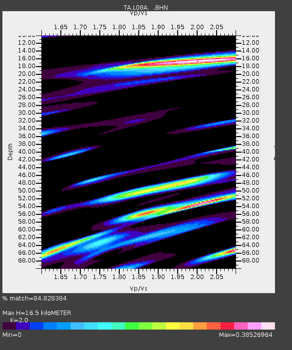
L08A Fields, OR, USA - Earthquake Result Viewer
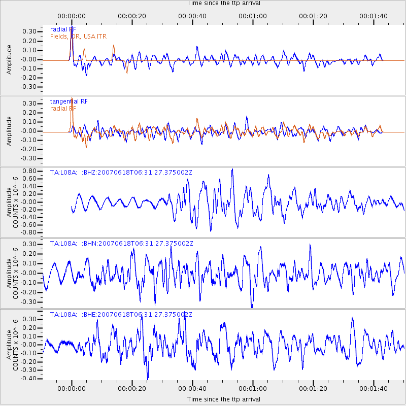
Earthquake location: New Ireland Region, P.N.G.
Earthquake latitude/longitude: -3.6/151.0
Earthquake time(UTC): 2007/06/18 (169) 06:18:48 GMT
Earthquake Depth: 26 km
Earthquake Magnitude: 5.7 MB, 6.2 MS, 6.3 MW, 6.1 MW
Earthquake Catalog/Contributor: WHDF/NEIC
Network: TA USArray Transportable Network (new EarthScope stations)
Station: L08A Fields, OR, USA
Lat/Lon: 42.19 N/118.34 W
Elevation: 1490 m
Distance: 92.9 deg
Az: 48.078 deg
Baz: 267.835 deg
Ray Param: 0.04136165
Estimated Moho Depth: 16.5 km
Estimated Crust Vp/Vs: 2.00
Assumed Crust Vp: 6.279 km/s
Estimated Crust Vs: 3.139 km/s
Estimated Crust Poisson's Ratio: 0.33
Radial Match: 84.828384 %
Radial Bump: 400
Transverse Match: 66.867256 %
Transverse Bump: 400
SOD ConfigId: 2564
Insert Time: 2010-03-07 02:46:41.172 +0000
GWidth: 2.5
Max Bumps: 400
Tol: 0.001

Signal To Noise

ChannelStoNSTALTA
TA:L08A: :BHN:20070618T06:31:27.375002Z1.10230977.1041185E-86.4447576E-8
TA:L08A: :BHE:20070618T06:31:27.375002Z0.899316254.798157E-85.335339E-8
TA:L08A: :BHZ:20070618T06:31:27.375002Z1.76552361.9658175E-71.1134474E-7
Arrivals
Ps2.7 SECOND
PpPs7.7 SECOND
PsPs/PpSs10 SECOND