You are here: Home > Network List > TA - USArray Transportable Network (new EarthScope stations) Stations List
> Station L08A Fields, OR, USA > Earthquake Result Viewer
L08A Fields, OR, USA - Earthquake Result Viewer
| Earthquake location: |
Near Coast Of Guatemala |
| Earthquake latitude/longitude: |
13.8/-90.8 |
| Earthquake time(UTC): |
2007/06/08 (159) 13:32:00 GMT |
| Earthquake Depth: |
48 km |
| Earthquake Magnitude: |
5.5 MB, 5.4 MS, 5.8 MW, 5.8 MW |
| Earthquake Catalog/Contributor: |
WHDF/NEIC |
|
| Network: |
TA USArray Transportable Network (new EarthScope stations) |
| Station: |
L08A Fields, OR, USA |
| Lat/Lon: |
42.19 N/118.34 W |
| Elevation: |
1490 m |
|
| Distance: |
37.0 deg |
| Az: |
325.113 deg |
| Baz: |
131.618 deg |
| Ray Param: |
0.07626924 |
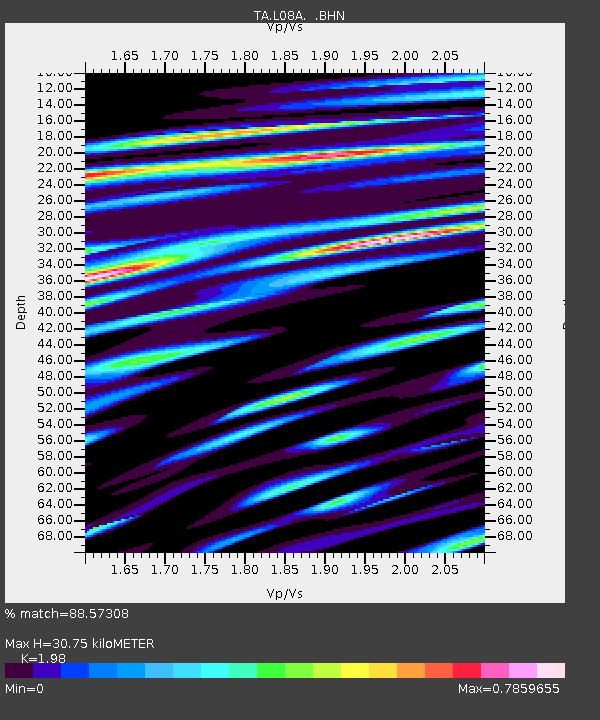
| Estimated Moho Depth: |
30.75 km |
| Estimated Crust Vp/Vs: |
1.98 |
| Assumed Crust Vp: |
6.279 km/s |
| Estimated Crust Vs: |
3.171 km/s |
| Estimated Crust Poisson's Ratio: |
0.33 |
|
| Radial Match: |
88.57308 % |
| Radial Bump: |
400 |
| Transverse Match: |
80.54468 % |
| Transverse Bump: |
400 |
| SOD ConfigId: |
2564 |
| Insert Time: |
2010-03-07 02:46:43.053 +0000 |
| GWidth: |
2.5 |
| Max Bumps: |
400 |
| Tol: |
0.001 |
|
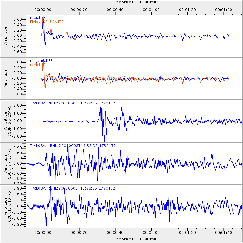
Signal To Noise
| Channel | StoN | STA | LTA |
| TA:L08A: :BHN:20070608T13:38:35.173015Z | 6.830362 | 3.6106368E-7 | 5.2861576E-8 |
| TA:L08A: :BHE:20070608T13:38:35.173015Z | 8.291667 | 4.2671113E-7 | 5.1462646E-8 |
| TA:L08A: :BHZ:20070608T13:38:35.173015Z | 20.576206 | 1.0843675E-6 | 5.270007E-8 |
| Arrivals |
| Ps | 5.1 SECOND |
| PpPs | 14 SECOND |
| PsPs/PpSs | 19 SECOND |


