You are here: Home > Network List > TA - USArray Transportable Network (new EarthScope stations) Stations List
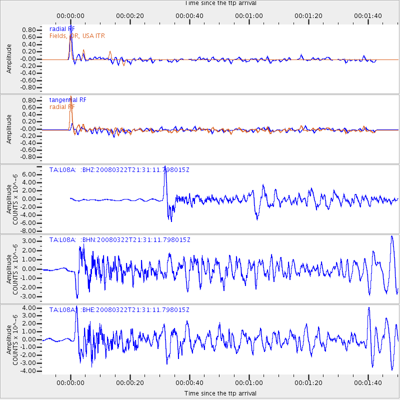
> Station L08A Fields, OR, USA > Earthquake Result Viewer
L08A Fields, OR, USA - Earthquake Result Viewer
| Earthquake location: |
Andreanof Islands, Aleutian Is. |
| Earthquake latitude/longitude: |
52.2/-178.7 |
| Earthquake time(UTC): |
2008/03/22 (082) 21:24:11 GMT |
| Earthquake Depth: |
132 km |
| Earthquake Magnitude: |
5.8 MB, 6.2 MW, 6.1 MW |
| Earthquake Catalog/Contributor: |
WHDF/NEIC |
|
| Network: |
TA USArray Transportable Network (new EarthScope stations) |
| Station: |
L08A Fields, OR, USA |
| Lat/Lon: |
42.19 N/118.34 W |
| Elevation: |
1490 m |
|
| Distance: |
41.1 deg |
| Az: |
79.256 deg |
| Baz: |
305.501 deg |
| Ray Param: |
0.073505186 |
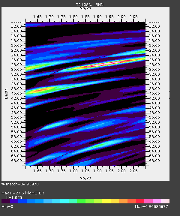
| Estimated Moho Depth: |
27.5 km |
| Estimated Crust Vp/Vs: |
1.92 |
| Assumed Crust Vp: |
6.279 km/s |
| Estimated Crust Vs: |
3.262 km/s |
| Estimated Crust Poisson's Ratio: |
0.32 |
|
| Radial Match: |
84.93978 % |
| Radial Bump: |
386 |
| Transverse Match: |
70.17437 % |
| Transverse Bump: |
400 |
| SOD ConfigId: |
2564 |
| Insert Time: |
2010-03-07 02:46:51.753 +0000 |
| GWidth: |
2.5 |
| Max Bumps: |
400 |
| Tol: |
0.001 |
|
Signal To Noise
| Channel | StoN | STA | LTA |
| TA:L08A: :BHN:20080322T21:31:11.798015Z | 5.601246 | 1.4666394E-6 | 2.6184165E-7 |
| TA:L08A: :BHE:20080322T21:31:11.798015Z | 12.627098 | 1.6856982E-6 | 1.3349846E-7 |
| TA:L08A: :BHZ:20080322T21:31:11.798015Z | 23.458857 | 3.3891681E-6 | 1.4447286E-7 |
| Arrivals |
| Ps | 4.3 SECOND |
| PpPs | 12 SECOND |
| PsPs/PpSs | 16 SECOND |


