You are here: Home > Network List > TA - USArray Transportable Network (new EarthScope stations) Stations List
> Station E29M Blow River, YT, CAN > Earthquake Result Viewer
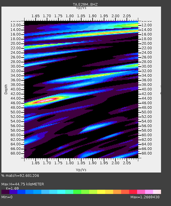
E29M Blow River, YT, CAN - Earthquake Result Viewer
| Earthquake location: |
Near East Coast Of Honshu, Japan |
| Earthquake latitude/longitude: |
37.7/141.5 |
| Earthquake time(UTC): |
2019/08/04 (216) 10:23:03 GMT |
| Earthquake Depth: |
39 km |
| Earthquake Magnitude: |
6.3 Mww |
| Earthquake Catalog/Contributor: |
NEIC PDE/us |
|
| Network: |
TA USArray Transportable Network (new EarthScope stations) |
| Station: |
E29M Blow River, YT, CAN |
| Lat/Lon: |
68.39 N/137.90 W |
| Elevation: |
324 m |
|
| Distance: |
52.1 deg |
| Az: |
27.586 deg |
| Baz: |
277.651 deg |
| Ray Param: |
0.06689242 |
| Estimated Moho Depth: |
44.75 km |
| Estimated Crust Vp/Vs: |
1.69 |
| Assumed Crust Vp: |
5.981 km/s |
| Estimated Crust Vs: |
3.539 km/s |
| Estimated Crust Poisson's Ratio: |
0.23 |
|
| Radial Match: |
92.681206 % |
| Radial Bump: |
400 |
| Transverse Match: |
91.56211 % |
| Transverse Bump: |
400 |
| SOD ConfigId: |
19053131 |
| Insert Time: |
2019-08-18 10:34:05.070 +0000 |
| GWidth: |
2.5 |
| Max Bumps: |
400 |
| Tol: |
0.001 |
|

Signal To Noise
| Channel | StoN | STA | LTA |
| TA:E29M: :BHZ:20190804T10:31:39.549988Z | 10.255052 | 7.565227E-7 | 7.3770735E-8 |
| TA:E29M: :BHN:20190804T10:31:39.549988Z | 1.4188501 | 1.2161783E-7 | 8.5715776E-8 |
| TA:E29M: :BHE:20190804T10:31:39.549988Z | 4.983365 | 3.5759697E-7 | 7.175814E-8 |
| Arrivals |
| Ps | 5.4 SECOND |
| PpPs | 19 SECOND |
| PsPs/PpSs | 25 SECOND |


