You are here: Home > Network List > TA - USArray Transportable Network (new EarthScope stations) Stations List
> Station F20K Avaraart Lake, AK, USA > Earthquake Result Viewer
F20K Avaraart Lake, AK, USA - Earthquake Result Viewer
| Earthquake location: |
Near East Coast Of Honshu, Japan |
| Earthquake latitude/longitude: |
37.7/141.5 |
| Earthquake time(UTC): |
2019/08/04 (216) 10:23:03 GMT |
| Earthquake Depth: |
39 km |
| Earthquake Magnitude: |
6.3 Mww |
| Earthquake Catalog/Contributor: |
NEIC PDE/us |
|
| Network: |
TA USArray Transportable Network (new EarthScope stations) |
| Station: |
F20K Avaraart Lake, AK, USA |
| Lat/Lon: |
67.05 N/155.73 W |
| Elevation: |
136 m |
|
| Distance: |
45.3 deg |
| Az: |
29.354 deg |
| Baz: |
262.318 deg |
| Ray Param: |
0.07126078 |
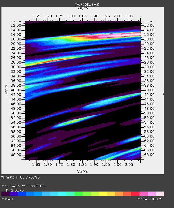
| Estimated Moho Depth: |
15.75 km |
| Estimated Crust Vp/Vs: |
2.02 |
| Assumed Crust Vp: |
6.522 km/s |
| Estimated Crust Vs: |
3.233 km/s |
| Estimated Crust Poisson's Ratio: |
0.34 |
|
| Radial Match: |
85.775795 % |
| Radial Bump: |
333 |
| Transverse Match: |
78.65654 % |
| Transverse Bump: |
400 |
| SOD ConfigId: |
19053131 |
| Insert Time: |
2019-08-18 10:34:08.772 +0000 |
| GWidth: |
2.5 |
| Max Bumps: |
400 |
| Tol: |
0.001 |
|

Signal To Noise
| Channel | StoN | STA | LTA |
| TA:F20K: :BHZ:20190804T10:30:47.625Z | 6.1552405 | 6.265918E-7 | 1.01798115E-7 |
| TA:F20K: :BHN:20190804T10:30:47.625Z | 1.000173 | 1.1517929E-7 | 1.15159374E-7 |
| TA:F20K: :BHE:20190804T10:30:47.625Z | 3.1741185 | 4.2983885E-7 | 1.3541991E-7 |
| Arrivals |
| Ps | 2.6 SECOND |
| PpPs | 6.9 SECOND |
| PsPs/PpSs | 9.5 SECOND |


