You are here: Home > Network List > TA - USArray Transportable Network (new EarthScope stations) Stations List
> Station F31M Tsiigehtchic, NWT, CAN > Earthquake Result Viewer
F31M Tsiigehtchic, NWT, CAN - Earthquake Result Viewer
| Earthquake location: |
Near East Coast Of Honshu, Japan |
| Earthquake latitude/longitude: |
37.7/141.5 |
| Earthquake time(UTC): |
2019/08/04 (216) 10:23:03 GMT |
| Earthquake Depth: |
39 km |
| Earthquake Magnitude: |
6.3 Mww |
| Earthquake Catalog/Contributor: |
NEIC PDE/us |
|
| Network: |
TA USArray Transportable Network (new EarthScope stations) |
| Station: |
F31M Tsiigehtchic, NWT, CAN |
| Lat/Lon: |
67.44 N/133.74 W |
| Elevation: |
56 m |
|
| Distance: |
53.8 deg |
| Az: |
28.425 deg |
| Baz: |
282.003 deg |
| Ray Param: |
0.06576479 |
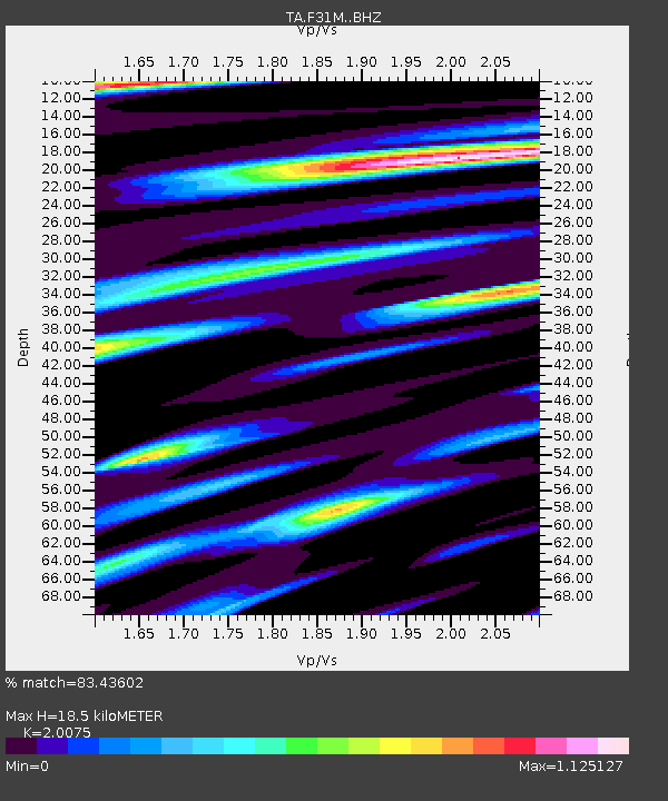
| Estimated Moho Depth: |
18.5 km |
| Estimated Crust Vp/Vs: |
2.01 |
| Assumed Crust Vp: |
6.171 km/s |
| Estimated Crust Vs: |
3.074 km/s |
| Estimated Crust Poisson's Ratio: |
0.33 |
|
| Radial Match: |
83.43602 % |
| Radial Bump: |
400 |
| Transverse Match: |
80.11088 % |
| Transverse Bump: |
400 |
| SOD ConfigId: |
19053131 |
| Insert Time: |
2019-08-18 10:34:13.484 +0000 |
| GWidth: |
2.5 |
| Max Bumps: |
400 |
| Tol: |
0.001 |
|
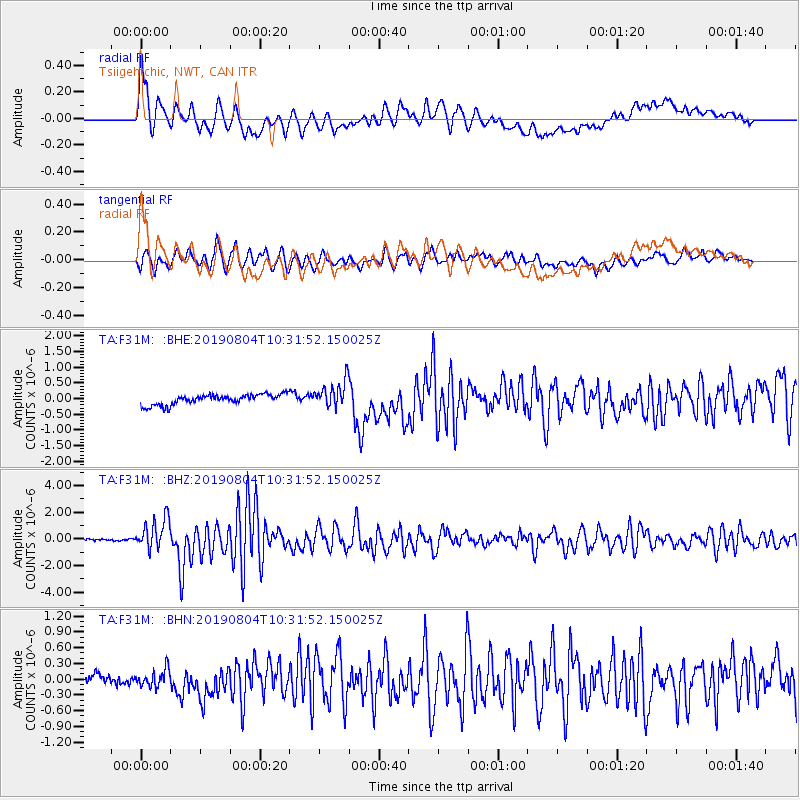
Signal To Noise
| Channel | StoN | STA | LTA |
| TA:F31M: :BHZ:20190804T10:31:52.150025Z | 18.807632 | 1.1623147E-6 | 6.180016E-8 |
| TA:F31M: :BHN:20190804T10:31:52.150025Z | 1.5555552 | 1.6058422E-7 | 1.03232736E-7 |
| TA:F31M: :BHE:20190804T10:31:52.150025Z | 2.564262 | 4.203868E-7 | 1.6394067E-7 |
| Arrivals |
| Ps | 3.2 SECOND |
| PpPs | 8.6 SECOND |
| PsPs/PpSs | 12 SECOND |


