You are here: Home > Network List > TA - USArray Transportable Network (new EarthScope stations) Stations List
> Station G27K Doyon Strip, AK, USA > Earthquake Result Viewer
G27K Doyon Strip, AK, USA - Earthquake Result Viewer
| Earthquake location: |
Near East Coast Of Honshu, Japan |
| Earthquake latitude/longitude: |
37.7/141.5 |
| Earthquake time(UTC): |
2019/08/04 (216) 10:23:03 GMT |
| Earthquake Depth: |
39 km |
| Earthquake Magnitude: |
6.3 Mww |
| Earthquake Catalog/Contributor: |
NEIC PDE/us |
|
| Network: |
TA USArray Transportable Network (new EarthScope stations) |
| Station: |
G27K Doyon Strip, AK, USA |
| Lat/Lon: |
66.81 N/141.65 W |
| Elevation: |
686 m |
|
| Distance: |
50.9 deg |
| Az: |
29.813 deg |
| Baz: |
275.566 deg |
| Ray Param: |
0.06769784 |
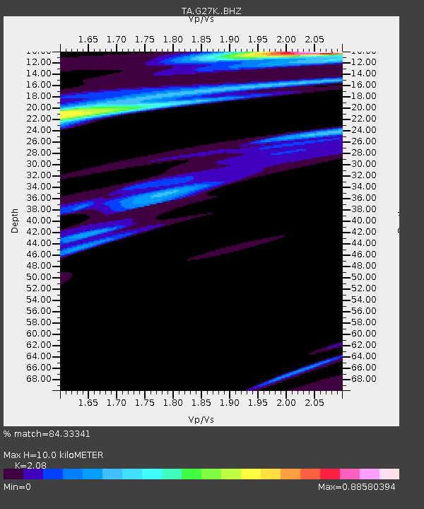
| Estimated Moho Depth: |
10.0 km |
| Estimated Crust Vp/Vs: |
2.08 |
| Assumed Crust Vp: |
6.577 km/s |
| Estimated Crust Vs: |
3.162 km/s |
| Estimated Crust Poisson's Ratio: |
0.35 |
|
| Radial Match: |
84.33341 % |
| Radial Bump: |
400 |
| Transverse Match: |
67.436905 % |
| Transverse Bump: |
400 |
| SOD ConfigId: |
19053131 |
| Insert Time: |
2019-08-18 10:34:19.367 +0000 |
| GWidth: |
2.5 |
| Max Bumps: |
400 |
| Tol: |
0.001 |
|

Signal To Noise
| Channel | StoN | STA | LTA |
| TA:G27K: :BHZ:20190804T10:31:30.250Z | 6.167621 | 3.5926894E-7 | 5.8250816E-8 |
| TA:G27K: :BHN:20190804T10:31:30.250Z | 2.6168272 | 2.382488E-7 | 9.104491E-8 |
| TA:G27K: :BHE:20190804T10:31:30.250Z | 1.4468708 | 2.1713677E-7 | 1.5007338E-7 |
| Arrivals |
| Ps | 1.7 SECOND |
| PpPs | 4.5 SECOND |
| PsPs/PpSs | 6.2 SECOND |


