You are here: Home > Network List > TA - USArray Transportable Network (new EarthScope stations) Stations List
> Station K20K Telida, AK, USA > Earthquake Result Viewer
K20K Telida, AK, USA - Earthquake Result Viewer
| Earthquake location: |
Near East Coast Of Honshu, Japan |
| Earthquake latitude/longitude: |
37.7/141.5 |
| Earthquake time(UTC): |
2019/08/04 (216) 10:23:03 GMT |
| Earthquake Depth: |
39 km |
| Earthquake Magnitude: |
6.3 Mww |
| Earthquake Catalog/Contributor: |
NEIC PDE/us |
|
| Network: |
TA USArray Transportable Network (new EarthScope stations) |
| Station: |
K20K Telida, AK, USA |
| Lat/Lon: |
63.36 N/154.07 W |
| Elevation: |
548 m |
|
| Distance: |
45.7 deg |
| Az: |
34.618 deg |
| Baz: |
267.51 deg |
| Ray Param: |
0.07102057 |
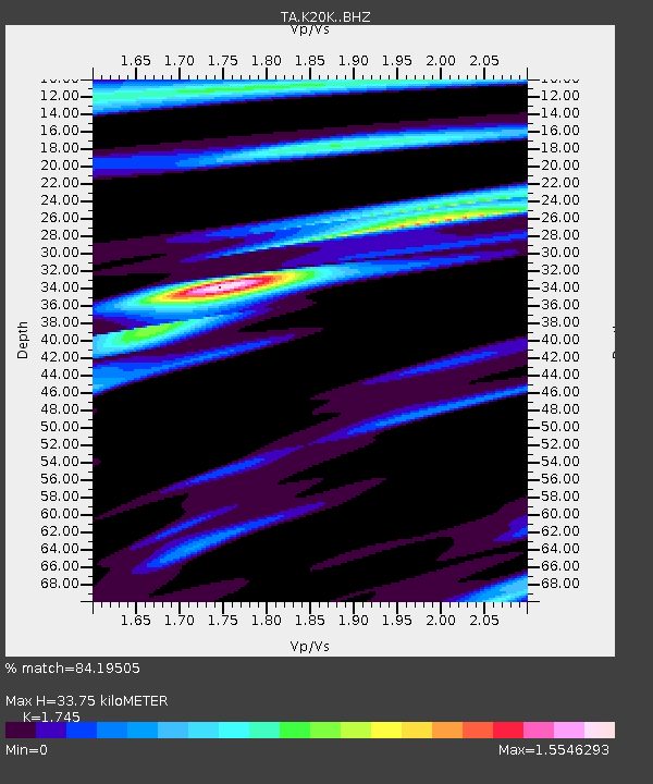
| Estimated Moho Depth: |
33.75 km |
| Estimated Crust Vp/Vs: |
1.75 |
| Assumed Crust Vp: |
6.438 km/s |
| Estimated Crust Vs: |
3.69 km/s |
| Estimated Crust Poisson's Ratio: |
0.26 |
|
| Radial Match: |
84.19505 % |
| Radial Bump: |
321 |
| Transverse Match: |
55.058777 % |
| Transverse Bump: |
346 |
| SOD ConfigId: |
19053131 |
| Insert Time: |
2019-08-18 10:34:38.576 +0000 |
| GWidth: |
2.5 |
| Max Bumps: |
400 |
| Tol: |
0.001 |
|

Signal To Noise
| Channel | StoN | STA | LTA |
| TA:K20K: :BHZ:20190804T10:30:50.524994Z | 3.419694 | 6.1696966E-7 | 1.8041663E-7 |
| TA:K20K: :BHN:20190804T10:30:50.524994Z | 1.1789706 | 3.3959077E-7 | 2.8804007E-7 |
| TA:K20K: :BHE:20190804T10:30:50.524994Z | 1.9444684 | 3.841456E-7 | 1.9755817E-7 |
| Arrivals |
| Ps | 4.2 SECOND |
| PpPs | 13 SECOND |
| PsPs/PpSs | 18 SECOND |


