You are here: Home > Network List > TA - USArray Transportable Network (new EarthScope stations) Stations List
> Station M26K Nabesna, AK, USA > Earthquake Result Viewer
M26K Nabesna, AK, USA - Earthquake Result Viewer
| Earthquake location: |
Near East Coast Of Honshu, Japan |
| Earthquake latitude/longitude: |
37.7/141.5 |
| Earthquake time(UTC): |
2019/08/04 (216) 10:23:03 GMT |
| Earthquake Depth: |
39 km |
| Earthquake Magnitude: |
6.3 Mww |
| Earthquake Catalog/Contributor: |
NEIC PDE/us |
|
| Network: |
TA USArray Transportable Network (new EarthScope stations) |
| Station: |
M26K Nabesna, AK, USA |
| Lat/Lon: |
62.40 N/143.00 W |
| Elevation: |
888 m |
|
| Distance: |
50.8 deg |
| Az: |
35.57 deg |
| Baz: |
277.993 deg |
| Ray Param: |
0.06773025 |
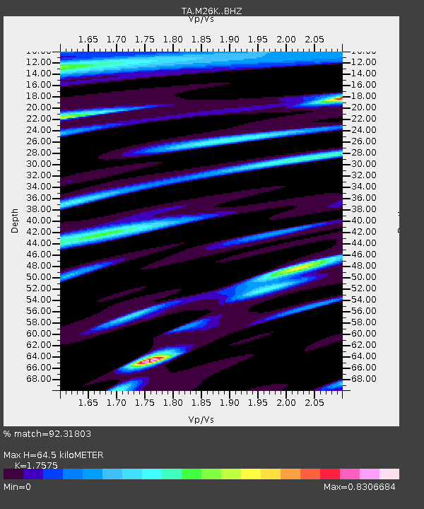
| Estimated Moho Depth: |
64.5 km |
| Estimated Crust Vp/Vs: |
1.76 |
| Assumed Crust Vp: |
6.566 km/s |
| Estimated Crust Vs: |
3.736 km/s |
| Estimated Crust Poisson's Ratio: |
0.26 |
|
| Radial Match: |
92.31803 % |
| Radial Bump: |
365 |
| Transverse Match: |
82.73368 % |
| Transverse Bump: |
400 |
| SOD ConfigId: |
19053131 |
| Insert Time: |
2019-08-18 10:34:47.635 +0000 |
| GWidth: |
2.5 |
| Max Bumps: |
400 |
| Tol: |
0.001 |
|

Signal To Noise
| Channel | StoN | STA | LTA |
| TA:M26K: :BHZ:20190804T10:31:29.850007Z | 8.37426 | 4.755797E-7 | 5.6790658E-8 |
| TA:M26K: :BHN:20190804T10:31:29.850007Z | 1.7090721 | 9.50061E-8 | 5.558929E-8 |
| TA:M26K: :BHE:20190804T10:31:29.850007Z | 3.074961 | 2.1448682E-7 | 6.9752694E-8 |
| Arrivals |
| Ps | 7.9 SECOND |
| PpPs | 26 SECOND |
| PsPs/PpSs | 33 SECOND |


