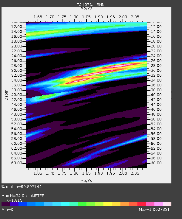
L07A Adel, OR, USA - Earthquake Result Viewer
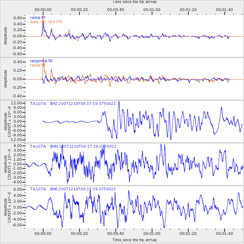
Earthquake location: Andreanof Islands, Aleutian Is.
Earthquake latitude/longitude: 51.4/-179.5
Earthquake time(UTC): 2007/12/19 (353) 09:30:27 GMT
Earthquake Depth: 29 km
Earthquake Magnitude: 6.4 MB, 7.1 MS, 7.1 MW, 7.0 MW
Earthquake Catalog/Contributor: WHDF/NEIC
Network: TA USArray Transportable Network (new EarthScope stations)
Station: L07A Adel, OR, USA
Lat/Lon: 42.02 N/119.34 W
Elevation: 1816 m
Distance: 41.2 deg
Az: 78.679 deg
Baz: 304.413 deg
Ray Param: 0.07385442
Estimated Moho Depth: 34.0 km
Estimated Crust Vp/Vs: 1.82
Assumed Crust Vp: 6.279 km/s
Estimated Crust Vs: 3.459 km/s
Estimated Crust Poisson's Ratio: 0.28
Radial Match: 90.807144 %
Radial Bump: 400
Transverse Match: 69.821785 %
Transverse Bump: 400
SOD ConfigId: 2564
Insert Time: 2010-03-07 02:47:12.451 +0000
GWidth: 2.5
Max Bumps: 400
Tol: 0.001

Signal To Noise

ChannelStoNSTALTA
TA:L07A: :BHN:20071219T09:37:39.075002Z2.28000041.1559938E-65.070147E-7
TA:L07A: :BHE:20071219T09:37:39.075002Z2.81870841.726154E-66.1239183E-7
TA:L07A: :BHZ:20071219T09:37:39.075002Z8.8060163.407809E-63.8698644E-7
Arrivals
Ps4.7 SECOND
PpPs14 SECOND
PsPs/PpSs19 SECOND