You are here: Home > Network List > TA - USArray Transportable Network (new EarthScope stations) Stations List
> Station P17K Kvichak River, AK, USA > Earthquake Result Viewer
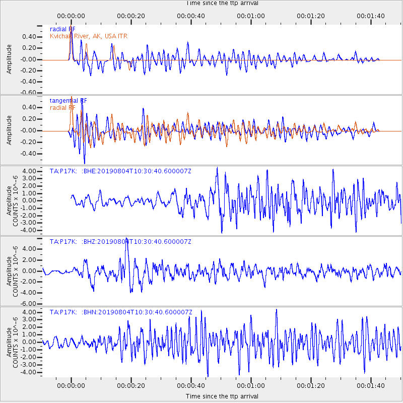
P17K Kvichak River, AK, USA - Earthquake Result Viewer
*The percent match for this event was below the threshold and hence no stack was calculated.
| Earthquake location: |
Near East Coast Of Honshu, Japan |
| Earthquake latitude/longitude: |
37.7/141.5 |
| Earthquake time(UTC): |
2019/08/04 (216) 10:23:03 GMT |
| Earthquake Depth: |
39 km |
| Earthquake Magnitude: |
6.3 Mww |
| Earthquake Catalog/Contributor: |
NEIC PDE/us |
|
| Network: |
TA USArray Transportable Network (new EarthScope stations) |
| Station: |
P17K Kvichak River, AK, USA |
| Lat/Lon: |
59.20 N/156.44 W |
| Elevation: |
91 m |
|
| Distance: |
44.4 deg |
| Az: |
40.474 deg |
| Baz: |
269.572 deg |
| Ray Param: |
$rayparam |
*The percent match for this event was below the threshold and hence was not used in the summary stack. |
|
| Radial Match: |
66.62702 % |
| Radial Bump: |
400 |
| Transverse Match: |
65.021416 % |
| Transverse Bump: |
400 |
| SOD ConfigId: |
19053131 |
| Insert Time: |
2019-08-18 10:34:56.719 +0000 |
| GWidth: |
2.5 |
| Max Bumps: |
400 |
| Tol: |
0.001 |
|
Signal To Noise
| Channel | StoN | STA | LTA |
| TA:P17K: :BHZ:20190804T10:30:40.600007Z | 3.0668266 | 8.3689014E-7 | 2.7288473E-7 |
| TA:P17K: :BHN:20190804T10:30:40.600007Z | 0.7886052 | 4.2930975E-7 | 5.443912E-7 |
| TA:P17K: :BHE:20190804T10:30:40.600007Z | 1.5429728 | 7.7406946E-7 | 5.016741E-7 |
| Arrivals |
| Ps | |
| PpPs | |
| PsPs/PpSs | |


