You are here: Home > Network List > TA - USArray Transportable Network (new EarthScope stations) Stations List
> Station L07A Adel, OR, USA > Earthquake Result Viewer
L07A Adel, OR, USA - Earthquake Result Viewer
| Earthquake location: |
Northern Chile |
| Earthquake latitude/longitude: |
-22.2/-69.9 |
| Earthquake time(UTC): |
2007/11/14 (318) 15:40:50 GMT |
| Earthquake Depth: |
40 km |
| Earthquake Magnitude: |
6.7 MB, 7.4 MS, 7.7 MW, 7.4 ME |
| Earthquake Catalog/Contributor: |
WHDF/NEIC |
|
| Network: |
TA USArray Transportable Network (new EarthScope stations) |
| Station: |
L07A Adel, OR, USA |
| Lat/Lon: |
42.02 N/119.34 W |
| Elevation: |
1816 m |
|
| Distance: |
78.6 deg |
| Az: |
324.718 deg |
| Baz: |
134.099 deg |
| Ray Param: |
0.04947275 |
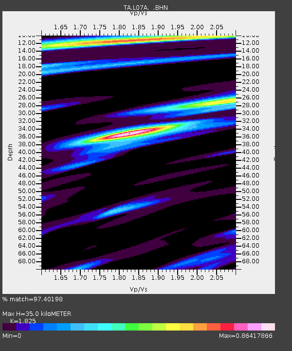
| Estimated Moho Depth: |
35.0 km |
| Estimated Crust Vp/Vs: |
1.83 |
| Assumed Crust Vp: |
6.279 km/s |
| Estimated Crust Vs: |
3.44 km/s |
| Estimated Crust Poisson's Ratio: |
0.29 |
|
| Radial Match: |
97.40198 % |
| Radial Bump: |
355 |
| Transverse Match: |
85.72117 % |
| Transverse Bump: |
400 |
| SOD ConfigId: |
2564 |
| Insert Time: |
2010-03-07 02:47:18.040 +0000 |
| GWidth: |
2.5 |
| Max Bumps: |
400 |
| Tol: |
0.001 |
|
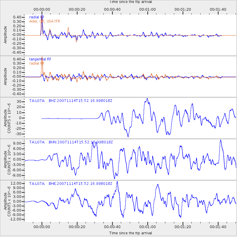
Signal To Noise
| Channel | StoN | STA | LTA |
| TA:L07A: :BHN:20071114T15:52:16.998018Z | 6.4486876 | 1.115085E-6 | 1.7291657E-7 |
| TA:L07A: :BHE:20071114T15:52:16.998018Z | 3.86459 | 1.3462961E-6 | 3.4836714E-7 |
| TA:L07A: :BHZ:20071114T15:52:16.998018Z | 27.670958 | 4.5353286E-6 | 1.6390213E-7 |
| Arrivals |
| Ps | 4.7 SECOND |
| PpPs | 15 SECOND |
| PsPs/PpSs | 20 SECOND |


