You are here: Home > Network List > UU - University of Utah Regional Network Stations List
> Station BRWY Blue Rim, WY, USA > Earthquake Result Viewer
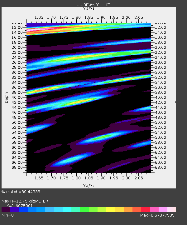
BRWY Blue Rim, WY, USA - Earthquake Result Viewer
| Earthquake location: |
Near East Coast Of Honshu, Japan |
| Earthquake latitude/longitude: |
37.7/141.5 |
| Earthquake time(UTC): |
2019/08/04 (216) 10:23:03 GMT |
| Earthquake Depth: |
39 km |
| Earthquake Magnitude: |
6.3 Mww |
| Earthquake Catalog/Contributor: |
NEIC PDE/us |
|
| Network: |
UU University of Utah Regional Network |
| Station: |
BRWY Blue Rim, WY, USA |
| Lat/Lon: |
41.62 N/109.50 W |
| Elevation: |
2098 m |
|
| Distance: |
77.9 deg |
| Az: |
46.491 deg |
| Baz: |
309.92 deg |
| Ray Param: |
0.049968056 |
| Estimated Moho Depth: |
12.75 km |
| Estimated Crust Vp/Vs: |
1.61 |
| Assumed Crust Vp: |
6.207 km/s |
| Estimated Crust Vs: |
3.861 km/s |
| Estimated Crust Poisson's Ratio: |
0.18 |
|
| Radial Match: |
80.44338 % |
| Radial Bump: |
400 |
| Transverse Match: |
65.34808 % |
| Transverse Bump: |
400 |
| SOD ConfigId: |
19053131 |
| Insert Time: |
2019-08-18 10:36:38.466 +0000 |
| GWidth: |
2.5 |
| Max Bumps: |
400 |
| Tol: |
0.001 |
|

Signal To Noise
| Channel | StoN | STA | LTA |
| UU:BRWY:01:HHZ:20190804T10:34:26.51001Z | 5.4186554 | 1.2531517E-8 | 2.3126618E-9 |
| UU:BRWY:01:HHN:20190804T10:34:26.51001Z | 0.99845093 | 6.20998E-9 | 6.2196146E-9 |
| UU:BRWY:01:HHE:20190804T10:34:26.51001Z | 0.78840905 | 2.5821378E-9 | 3.2751244E-9 |
| Arrivals |
| Ps | 1.3 SECOND |
| PpPs | 5.2 SECOND |
| PsPs/PpSs | 6.5 SECOND |


