You are here: Home > Network List > UU - University of Utah Regional Network Stations List
> Station CTU Camp Tracy, UT, USA > Earthquake Result Viewer
CTU Camp Tracy, UT, USA - Earthquake Result Viewer
| Earthquake location: |
Near East Coast Of Honshu, Japan |
| Earthquake latitude/longitude: |
37.7/141.5 |
| Earthquake time(UTC): |
2019/08/04 (216) 10:23:03 GMT |
| Earthquake Depth: |
39 km |
| Earthquake Magnitude: |
6.3 Mww |
| Earthquake Catalog/Contributor: |
NEIC PDE/us |
|
| Network: |
UU University of Utah Regional Network |
| Station: |
CTU Camp Tracy, UT, USA |
| Lat/Lon: |
40.69 N/111.75 W |
| Elevation: |
1731 m |
|
| Distance: |
77.1 deg |
| Az: |
48.329 deg |
| Baz: |
308.844 deg |
| Ray Param: |
0.050458685 |
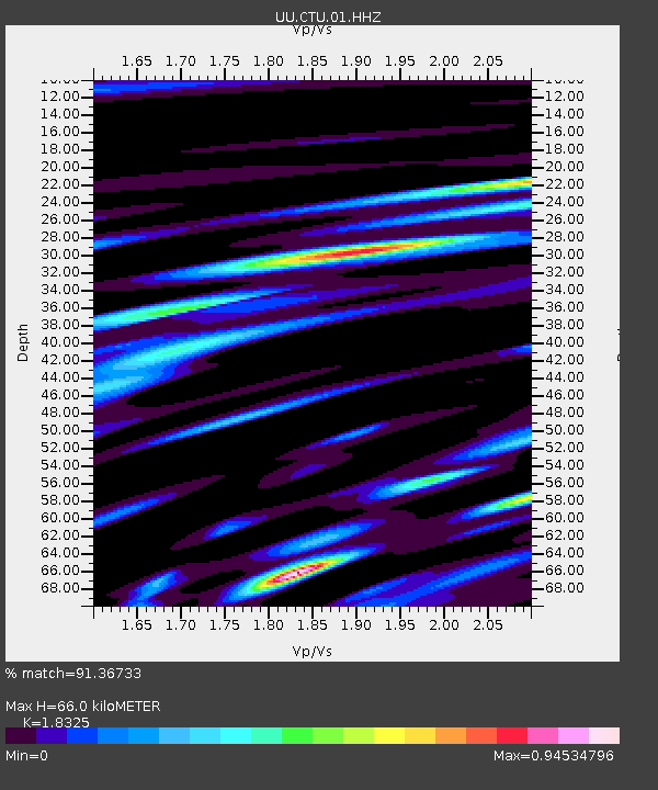
| Estimated Moho Depth: |
66.0 km |
| Estimated Crust Vp/Vs: |
1.83 |
| Assumed Crust Vp: |
6.155 km/s |
| Estimated Crust Vs: |
3.359 km/s |
| Estimated Crust Poisson's Ratio: |
0.29 |
|
| Radial Match: |
91.36733 % |
| Radial Bump: |
400 |
| Transverse Match: |
83.97 % |
| Transverse Bump: |
400 |
| SOD ConfigId: |
19053131 |
| Insert Time: |
2019-08-18 10:36:40.035 +0000 |
| GWidth: |
2.5 |
| Max Bumps: |
400 |
| Tol: |
0.001 |
|

Signal To Noise
| Channel | StoN | STA | LTA |
| UU:CTU:01:HHZ:20190804T10:34:22.494996Z | 3.9777997 | 7.351367E-9 | 1.8480989E-9 |
| UU:CTU:01:HHN:20190804T10:34:22.494996Z | 2.3511202 | 2.3688875E-9 | 1.0075569E-9 |
| UU:CTU:01:HHE:20190804T10:34:22.494996Z | 3.5346582 | 3.5773267E-9 | 1.0120714E-9 |
| Arrivals |
| Ps | 9.2 SECOND |
| PpPs | 30 SECOND |
| PsPs/PpSs | 39 SECOND |


