You are here: Home > Network List > TA - USArray Transportable Network (new EarthScope stations) Stations List
> Station L07A Adel, OR, USA > Earthquake Result Viewer
L07A Adel, OR, USA - Earthquake Result Viewer
| Earthquake location: |
Solomon Islands |
| Earthquake latitude/longitude: |
-7.3/155.7 |
| Earthquake time(UTC): |
2007/04/01 (091) 21:11:33 GMT |
| Earthquake Depth: |
10 km |
| Earthquake Magnitude: |
6.3 MB |
| Earthquake Catalog/Contributor: |
WHDF/NEIC |
|
| Network: |
TA USArray Transportable Network (new EarthScope stations) |
| Station: |
L07A Adel, OR, USA |
| Lat/Lon: |
42.02 N/119.34 W |
| Elevation: |
1816 m |
|
| Distance: |
91.1 deg |
| Az: |
47.933 deg |
| Baz: |
261.214 deg |
| Ray Param: |
0.04162784 |
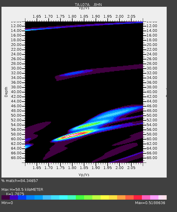
| Estimated Moho Depth: |
58.5 km |
| Estimated Crust Vp/Vs: |
1.79 |
| Assumed Crust Vp: |
6.279 km/s |
| Estimated Crust Vs: |
3.512 km/s |
| Estimated Crust Poisson's Ratio: |
0.27 |
|
| Radial Match: |
84.34657 % |
| Radial Bump: |
306 |
| Transverse Match: |
48.462505 % |
| Transverse Bump: |
204 |
| SOD ConfigId: |
2564 |
| Insert Time: |
2010-03-07 02:48:02.111 +0000 |
| GWidth: |
2.5 |
| Max Bumps: |
400 |
| Tol: |
0.001 |
|
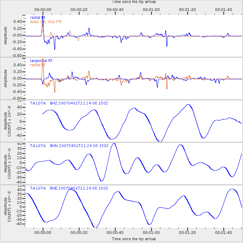
Signal To Noise
| Channel | StoN | STA | LTA |
| TA:L07A: :BHN:20070401T21:24:06.150Z | 0.65011716 | 6.833617E-6 | 1.0511362E-5 |
| TA:L07A: :BHE:20070401T21:24:06.150Z | 1.5288118 | 3.5126017E-5 | 2.2976023E-5 |
| TA:L07A: :BHZ:20070401T21:24:06.150Z | 0.9629073 | 1.9822202E-5 | 2.0585785E-5 |
| Arrivals |
| Ps | 7.5 SECOND |
| PpPs | 25 SECOND |
| PsPs/PpSs | 33 SECOND |


