You are here: Home > Network List > TA - USArray Transportable Network (new EarthScope stations) Stations List
> Station L07A Adel, OR, USA > Earthquake Result Viewer
L07A Adel, OR, USA - Earthquake Result Viewer
| Earthquake location: |
Solomon Islands |
| Earthquake latitude/longitude: |
-8.5/157.0 |
| Earthquake time(UTC): |
2007/04/01 (091) 20:39:56 GMT |
| Earthquake Depth: |
10 km |
| Earthquake Magnitude: |
6.8 MB, 7.9 MS, 8.1 MW, 7.7 ME |
| Earthquake Catalog/Contributor: |
WHDF/NEIC |
|
| Network: |
TA USArray Transportable Network (new EarthScope stations) |
| Station: |
L07A Adel, OR, USA |
| Lat/Lon: |
42.02 N/119.34 W |
| Elevation: |
1816 m |
|
| Distance: |
90.9 deg |
| Az: |
47.785 deg |
| Baz: |
259.497 deg |
| Ray Param: |
0.041641243 |
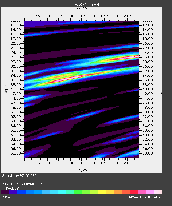
| Estimated Moho Depth: |
25.5 km |
| Estimated Crust Vp/Vs: |
2.08 |
| Assumed Crust Vp: |
6.279 km/s |
| Estimated Crust Vs: |
3.019 km/s |
| Estimated Crust Poisson's Ratio: |
0.35 |
|
| Radial Match: |
95.51481 % |
| Radial Bump: |
340 |
| Transverse Match: |
85.03636 % |
| Transverse Bump: |
400 |
| SOD ConfigId: |
2564 |
| Insert Time: |
2010-03-07 02:48:03.708 +0000 |
| GWidth: |
2.5 |
| Max Bumps: |
400 |
| Tol: |
0.001 |
|
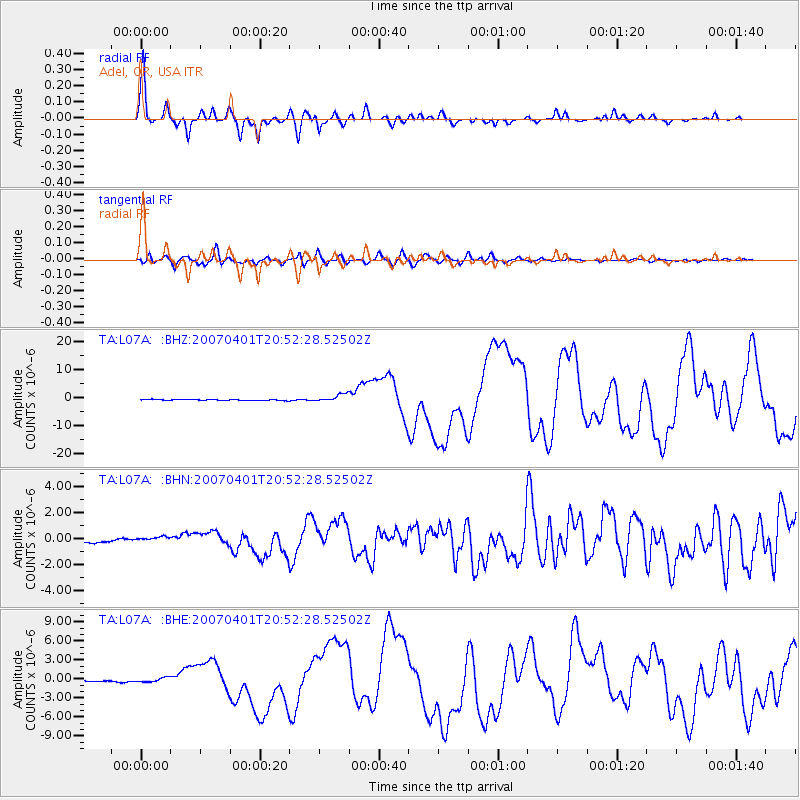
Signal To Noise
| Channel | StoN | STA | LTA |
| TA:L07A: :BHN:20070401T20:52:28.52502Z | 1.0824633 | 1.9668845E-7 | 1.817045E-7 |
| TA:L07A: :BHE:20070401T20:52:28.52502Z | 1.8035723 | 3.490697E-7 | 1.935435E-7 |
| TA:L07A: :BHZ:20070401T20:52:28.52502Z | 9.6319895 | 1.3977262E-6 | 1.4511294E-7 |
| Arrivals |
| Ps | 4.5 SECOND |
| PpPs | 12 SECOND |
| PsPs/PpSs | 17 SECOND |


