You are here: Home > Network List > UW - Pacific Northwest Regional Seismic Network Stations List
> Station YPT Yellepit > Earthquake Result Viewer
YPT Yellepit - Earthquake Result Viewer
| Earthquake location: |
Near East Coast Of Honshu, Japan |
| Earthquake latitude/longitude: |
37.7/141.5 |
| Earthquake time(UTC): |
2019/08/04 (216) 10:23:03 GMT |
| Earthquake Depth: |
39 km |
| Earthquake Magnitude: |
6.3 Mww |
| Earthquake Catalog/Contributor: |
NEIC PDE/us |
|
| Network: |
UW Pacific Northwest Regional Seismic Network |
| Station: |
YPT Yellepit |
| Lat/Lon: |
46.05 N/118.96 W |
| Elevation: |
330 m |
|
| Distance: |
69.7 deg |
| Az: |
47.07 deg |
| Baz: |
303.54 deg |
| Ray Param: |
0.055375975 |
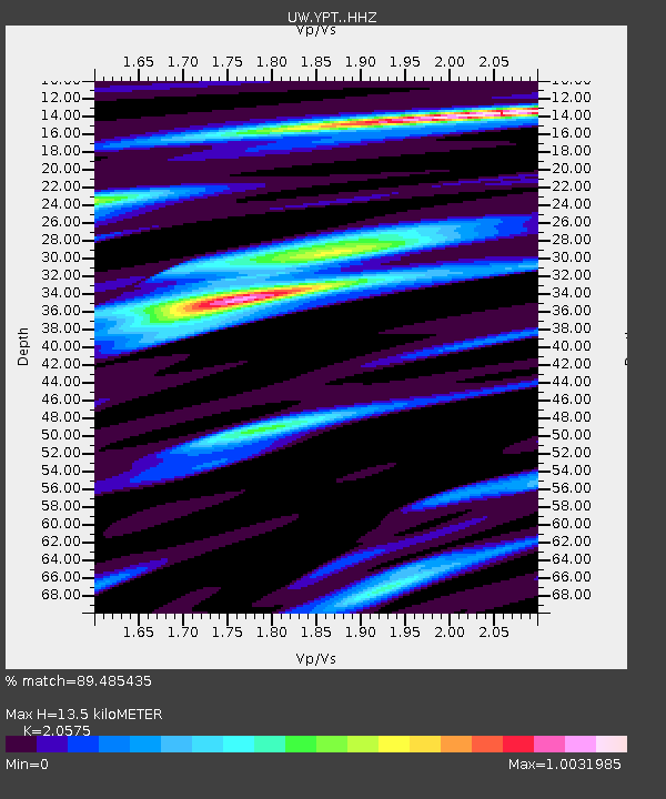
| Estimated Moho Depth: |
13.5 km |
| Estimated Crust Vp/Vs: |
2.06 |
| Assumed Crust Vp: |
6.419 km/s |
| Estimated Crust Vs: |
3.12 km/s |
| Estimated Crust Poisson's Ratio: |
0.35 |
|
| Radial Match: |
89.485435 % |
| Radial Bump: |
368 |
| Transverse Match: |
79.910324 % |
| Transverse Bump: |
400 |
| SOD ConfigId: |
19053131 |
| Insert Time: |
2019-08-18 10:37:15.921 +0000 |
| GWidth: |
2.5 |
| Max Bumps: |
400 |
| Tol: |
0.001 |
|

Signal To Noise
| Channel | StoN | STA | LTA |
| UW:YPT: :HHZ:20190804T10:33:39.080018Z | 3.6062727 | 3.5385688E-7 | 9.8122605E-8 |
| UW:YPT: :HHN:20190804T10:33:39.080018Z | 3.788742 | 1.5093607E-7 | 3.9838046E-8 |
| UW:YPT: :HHE:20190804T10:33:39.080018Z | 1.8498296 | 9.601485E-8 | 5.19047E-8 |
| Arrivals |
| Ps | 2.3 SECOND |
| PpPs | 6.2 SECOND |
| PsPs/PpSs | 8.5 SECOND |


