You are here: Home > Network List > YX16 - Raton Basin UNM Broadband Network Stations List
> Station UNM5 Southernmost CO Station > Earthquake Result Viewer
UNM5 Southernmost CO Station - Earthquake Result Viewer
| Earthquake location: |
Near East Coast Of Honshu, Japan |
| Earthquake latitude/longitude: |
37.7/141.5 |
| Earthquake time(UTC): |
2019/08/04 (216) 10:23:03 GMT |
| Earthquake Depth: |
39 km |
| Earthquake Magnitude: |
6.3 Mww |
| Earthquake Catalog/Contributor: |
NEIC PDE/us |
|
| Network: |
YX Raton Basin UNM Broadband Network |
| Station: |
UNM5 Southernmost CO Station |
| Lat/Lon: |
37.12 N/104.78 W |
| Elevation: |
2035 m |
|
| Distance: |
83.6 deg |
| Az: |
47.443 deg |
| Baz: |
313.059 deg |
| Ray Param: |
0.046024933 |
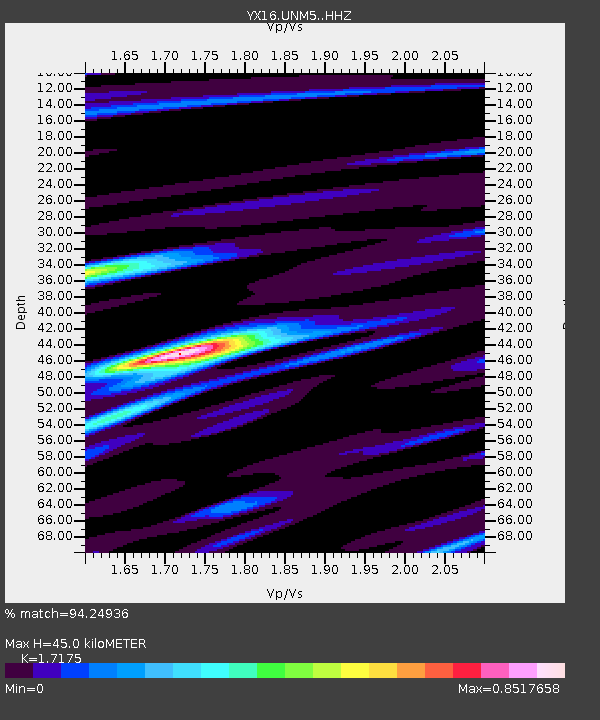
| Estimated Moho Depth: |
45.0 km |
| Estimated Crust Vp/Vs: |
1.72 |
| Assumed Crust Vp: |
6.316 km/s |
| Estimated Crust Vs: |
3.677 km/s |
| Estimated Crust Poisson's Ratio: |
0.24 |
|
| Radial Match: |
94.24936 % |
| Radial Bump: |
271 |
| Transverse Match: |
88.64092 % |
| Transverse Bump: |
339 |
| SOD ConfigId: |
19053131 |
| Insert Time: |
2019-08-18 10:37:50.678 +0000 |
| GWidth: |
2.5 |
| Max Bumps: |
400 |
| Tol: |
0.001 |
|

Signal To Noise
| Channel | StoN | STA | LTA |
| YX:UNM5: :HHZ:20190804T10:34:56.940003Z | 4.8572044 | 4.3054604E-7 | 8.864071E-8 |
| YX:UNM5: :HHN:20190804T10:34:56.940003Z | 1.5849327 | 7.622222E-8 | 4.809177E-8 |
| YX:UNM5: :HHE:20190804T10:34:56.940003Z | 1.0929058 | 9.1611746E-8 | 8.3824006E-8 |
| Arrivals |
| Ps | 5.2 SECOND |
| PpPs | 19 SECOND |
| PsPs/PpSs | 24 SECOND |


