You are here: Home > Network List > TA - USArray Transportable Network (new EarthScope stations) Stations List
> Station L07A Adel, OR, USA > Earthquake Result Viewer
L07A Adel, OR, USA - Earthquake Result Viewer
| Earthquake location: |
Kuril Islands |
| Earthquake latitude/longitude: |
46.6/153.3 |
| Earthquake time(UTC): |
2006/11/15 (319) 11:14:13 GMT |
| Earthquake Depth: |
10 km |
| Earthquake Magnitude: |
6.5 MB, 7.8 MS, 8.3 MW, 7.9 MW |
| Earthquake Catalog/Contributor: |
WHDF/NEIC |
|
| Network: |
TA USArray Transportable Network (new EarthScope stations) |
| Station: |
L07A Adel, OR, USA |
| Lat/Lon: |
42.02 N/119.34 W |
| Elevation: |
1816 m |
|
| Distance: |
59.6 deg |
| Az: |
59.678 deg |
| Baz: |
306.978 deg |
| Ray Param: |
0.062093094 |
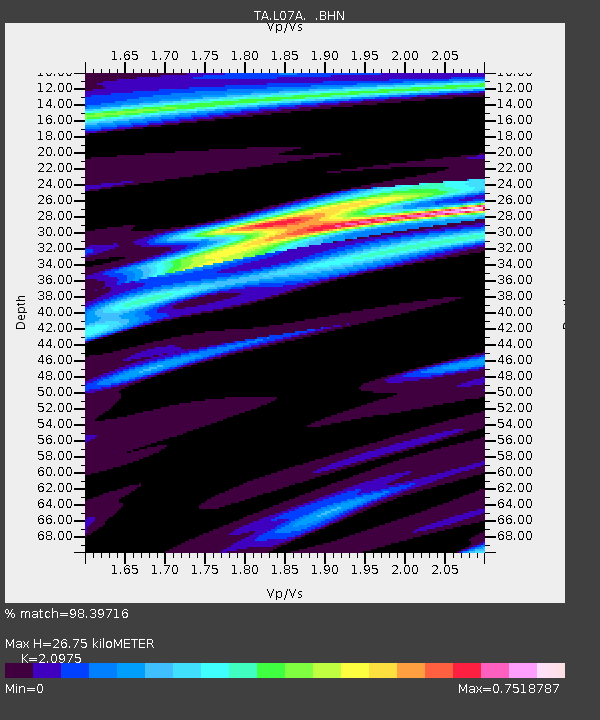
| Estimated Moho Depth: |
26.75 km |
| Estimated Crust Vp/Vs: |
2.10 |
| Assumed Crust Vp: |
6.279 km/s |
| Estimated Crust Vs: |
2.993 km/s |
| Estimated Crust Poisson's Ratio: |
0.35 |
|
| Radial Match: |
98.39716 % |
| Radial Bump: |
240 |
| Transverse Match: |
92.36314 % |
| Transverse Bump: |
400 |
| SOD ConfigId: |
2564 |
| Insert Time: |
2010-03-07 02:48:34.416 +0000 |
| GWidth: |
2.5 |
| Max Bumps: |
400 |
| Tol: |
0.001 |
|

Signal To Noise
| Channel | StoN | STA | LTA |
| TA:L07A: :BHN:20061115T11:23:46.249016Z | 1.0726265 | 2.1625885E-7 | 2.0161617E-7 |
| TA:L07A: :BHE:20061115T11:23:46.249016Z | 1.0941063 | 3.8689885E-7 | 3.5362086E-7 |
| TA:L07A: :BHZ:20061115T11:23:46.249016Z | 5.8646603 | 1.1569313E-6 | 1.9727166E-7 |
| Arrivals |
| Ps | 4.9 SECOND |
| PpPs | 13 SECOND |
| PsPs/PpSs | 18 SECOND |


