L07A Adel, OR, USA - Earthquake Result Viewer
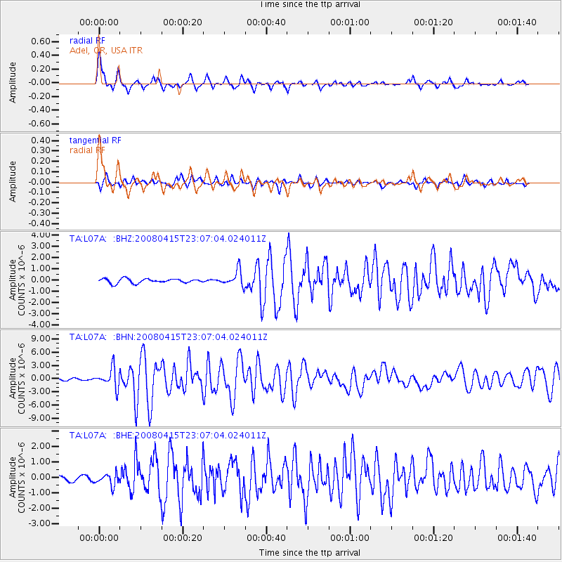
Earthquake location: Andreanof Islands, Aleutian Is.
Earthquake latitude/longitude: 51.9/-179.4
Earthquake time(UTC): 2008/04/15 (106) 22:59:51 GMT
Earthquake Depth: 10 km
Earthquake Magnitude: 6.1 MB, 6.4 MS, 6.4 MW, 6.4 MW
Earthquake Catalog/Contributor: WHDF/NEIC
Network: TA USArray Transportable Network (new EarthScope stations)
Station: L07A Adel, OR, USA
Lat/Lon: 42.02 N/119.34 W
Elevation: 1816 m
Distance: 41.1 deg
Az: 79.337 deg
Baz: 305.117 deg
Ray Param: 0.07403128
Estimated Moho Depth: 30.0 km
Estimated Crust Vp/Vs: 1.91
Assumed Crust Vp: 6.279 km/s
Estimated Crust Vs: 3.279 km/s
Estimated Crust Poisson's Ratio: 0.31
Radial Match: 91.137566 %
Radial Bump: 400
Transverse Match: 73.81974 %
Transverse Bump: 400
SOD ConfigId: 2504
Insert Time: 2010-03-07 02:48:40.965 +0000
GWidth: 2.5
Max Bumps: 400
Tol: 0.001

Signal To Noise

ChannelStoNSTALTA
TA:L07A: :BHN:20080415T23:07:04.024011Z10.5610332.2653153E-62.144975E-7
TA:L07A: :BHE:20080415T23:07:04.024011Z2.92658043.8519516E-71.3161954E-7
TA:L07A: :BHZ:20080415T23:07:04.024011Z3.76017267.324986E-71.9480451E-7
Arrivals
Ps4.6 SECOND
PpPs13 SECOND
PsPs/PpSs18 SECOND