You are here: Home > Network List > IU - Global Seismograph Network (GSN - IRIS/USGS) Stations List
> Station ANTO Ankara, Turkey > Earthquake Result Viewer
ANTO Ankara, Turkey - Earthquake Result Viewer
| Earthquake location: |
Sea Of Okhotsk |
| Earthquake latitude/longitude: |
53.4/152.8 |
| Earthquake time(UTC): |
2009/12/10 (344) 02:30:52 GMT |
| Earthquake Depth: |
656 km |
| Earthquake Magnitude: |
6.1 MB, 6.3 MW, 6.3 MW |
| Earthquake Catalog/Contributor: |
WHDF/NEIC |
|
| Network: |
IU Global Seismograph Network (GSN - IRIS/USGS) |
| Station: |
ANTO Ankara, Turkey |
| Lat/Lon: |
39.87 N/32.79 E |
| Elevation: |
1090 m |
|
| Distance: |
73.7 deg |
| Az: |
315.985 deg |
| Baz: |
32.711 deg |
| Ray Param: |
0.050610885 |
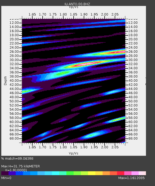
| Estimated Moho Depth: |
31.75 km |
| Estimated Crust Vp/Vs: |
1.91 |
| Assumed Crust Vp: |
6.159 km/s |
| Estimated Crust Vs: |
3.224 km/s |
| Estimated Crust Poisson's Ratio: |
0.31 |
|
| Radial Match: |
89.06398 % |
| Radial Bump: |
400 |
| Transverse Match: |
85.43664 % |
| Transverse Bump: |
400 |
| SOD ConfigId: |
1 |
| Insert Time: |
2010-02-19 01:22:25.499 +0000 |
| GWidth: |
2.5 |
| Max Bumps: |
400 |
| Tol: |
0.001 |
|
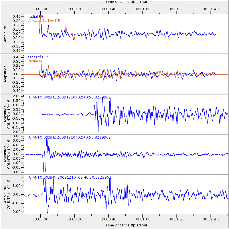
Signal To Noise
| Channel | StoN | STA | LTA |
| IU:ANTO:00:BHZ:20091210T02:40:50.822996Z | 52.77456 | 3.5899907E-6 | 6.802503E-8 |
| IU:ANTO:00:BHN:20091210T02:40:50.822996Z | 14.217825 | 1.0303901E-6 | 7.247171E-8 |
| IU:ANTO:00:BHE:20091210T02:40:50.822996Z | 13.105999 | 6.9554767E-7 | 5.3070938E-8 |
| Arrivals |
| Ps | 4.8 SECOND |
| PpPs | 15 SECOND |
| PsPs/PpSs | 19 SECOND |


