You are here: Home > Network List > US - United States National Seismic Network Stations List
> Station HAWA Hanford, Washington, USA > Earthquake Result Viewer
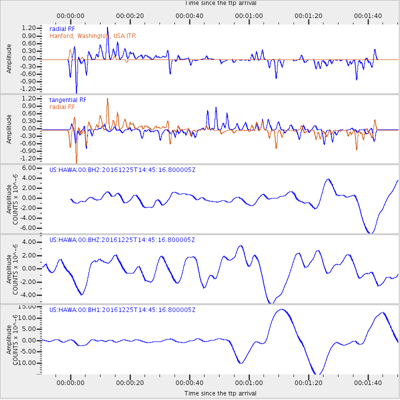
HAWA Hanford, Washington, USA - Earthquake Result Viewer
*The percent match for this event was below the threshold and hence no stack was calculated.
| Earthquake location: |
Southern Chile |
| Earthquake latitude/longitude: |
-43.5/-74.5 |
| Earthquake time(UTC): |
2016/12/25 (360) 14:32:13 GMT |
| Earthquake Depth: |
17 km |
| Earthquake Magnitude: |
5.6 mb |
| Earthquake Catalog/Contributor: |
NEIC PDE/us |
|
| Network: |
US United States National Seismic Network |
| Station: |
HAWA Hanford, Washington, USA |
| Lat/Lon: |
46.39 N/119.53 W |
| Elevation: |
364 m |
|
| Distance: |
98.0 deg |
| Az: |
330.366 deg |
| Baz: |
148.674 deg |
| Ray Param: |
$rayparam |
*The percent match for this event was below the threshold and hence was not used in the summary stack. |
|
| Radial Match: |
76.91758 % |
| Radial Bump: |
392 |
| Transverse Match: |
82.83813 % |
| Transverse Bump: |
400 |
| SOD ConfigId: |
1894071 |
| Insert Time: |
2017-01-08 14:37:39.818 +0000 |
| GWidth: |
2.5 |
| Max Bumps: |
400 |
| Tol: |
0.001 |
|
Signal To Noise
| Channel | StoN | STA | LTA |
| US:HAWA:00:BHZ:20161225T14:45:16.800005Z | 2.3304853 | 2.6374137E-6 | 1.1317015E-6 |
| US:HAWA:00:BH1:20161225T14:45:16.800005Z | 2.1434746 | 1.3104002E-6 | 6.11344E-7 |
| US:HAWA:00:BH2:20161225T14:45:16.800005Z | 1.2384768 | 8.407902E-7 | 6.788907E-7 |
| Arrivals |
| Ps | |
| PpPs | |
| PsPs/PpSs | |


