You are here: Home > Network List > TA - USArray Transportable Network (new EarthScope stations) Stations List
> Station G07A Ruggs Ranch, Heppner, OR, USA > Earthquake Result Viewer
G07A Ruggs Ranch, Heppner, OR, USA - Earthquake Result Viewer

| Earthquake location: |
Solomon Islands |
| Earthquake latitude/longitude: |
-9.8/159.5 |
| Earthquake time(UTC): |
2007/08/16 (228) 08:39:27 GMT |
| Earthquake Depth: |
10 km |
| Earthquake Magnitude: |
6.1 MB, 6.7 MS, 6.4 MW |
| Earthquake Catalog/Contributor: |
WHDF/NEIC |
|
| Network: |
TA USArray Transportable Network (new EarthScope stations) |
| Station: |
G07A Ruggs Ranch, Heppner, OR, USA |
| Lat/Lon: |
45.27 N/119.67 W |
| Elevation: |
801 m |
|
| Distance: |
90.5 deg |
| Az: |
44.208 deg |
| Baz: |
256.669 deg |
| Ray Param: |
0.041665442 |
| Estimated Moho Depth: |
20.25 km |
| Estimated Crust Vp/Vs: |
1.60 |
| Assumed Crust Vp: |
6.571 km/s |
| Estimated Crust Vs: |
4.107 km/s |
| Estimated Crust Poisson's Ratio: |
0.18 |
|
| Radial Match: |
91.92793 % |
| Radial Bump: |
379 |
| Transverse Match: |
83.20905 % |
| Transverse Bump: |
400 |
| SOD ConfigId: |
2564 |
| Insert Time: |
2010-03-07 02:49:30.849 +0000 |
| GWidth: |
2.5 |
| Max Bumps: |
400 |
| Tol: |
0.001 |
|
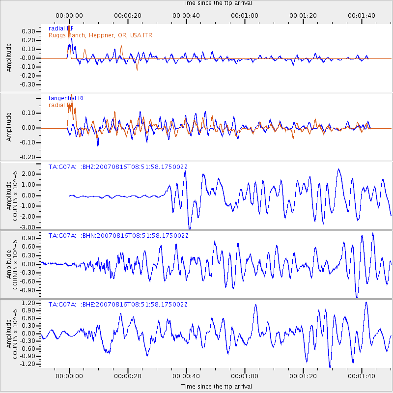
Signal To Noise
| Channel | StoN | STA | LTA |
| TA:G07A: :BHN:20070816T08:51:58.175002Z | 0.7360544 | 4.643097E-8 | 6.308089E-8 |
| TA:G07A: :BHE:20070816T08:51:58.175002Z | 1.2403171 | 9.7190544E-8 | 7.835943E-8 |
| TA:G07A: :BHZ:20070816T08:51:58.175002Z | 6.2229195 | 4.3457166E-7 | 6.983405E-8 |
| Arrivals |
| Ps | 1.9 SECOND |
| PpPs | 7.8 SECOND |
| PsPs/PpSs | 9.7 SECOND |


