You are here: Home > Network List > TA - USArray Transportable Network (new EarthScope stations) Stations List
> Station G07A Ruggs Ranch, Heppner, OR, USA > Earthquake Result Viewer
G07A Ruggs Ranch, Heppner, OR, USA - Earthquake Result Viewer

| Earthquake location: |
South Of Fiji Islands |
| Earthquake latitude/longitude: |
-26.3/-177.7 |
| Earthquake time(UTC): |
2007/07/18 (199) 00:07:35 GMT |
| Earthquake Depth: |
10 km |
| Earthquake Magnitude: |
5.8 MB, 5.9 MS, 6.1 MW, 6.0 MW |
| Earthquake Catalog/Contributor: |
WHDF/NEIC |
|
| Network: |
TA USArray Transportable Network (new EarthScope stations) |
| Station: |
G07A Ruggs Ranch, Heppner, OR, USA |
| Lat/Lon: |
45.27 N/119.67 W |
| Elevation: |
801 m |
|
| Distance: |
88.7 deg |
| Az: |
36.834 deg |
| Baz: |
229.647 deg |
| Ray Param: |
0.042419244 |
| Estimated Moho Depth: |
20.25 km |
| Estimated Crust Vp/Vs: |
1.74 |
| Assumed Crust Vp: |
6.571 km/s |
| Estimated Crust Vs: |
3.787 km/s |
| Estimated Crust Poisson's Ratio: |
0.25 |
|
| Radial Match: |
80.03148 % |
| Radial Bump: |
400 |
| Transverse Match: |
76.824326 % |
| Transverse Bump: |
400 |
| SOD ConfigId: |
2564 |
| Insert Time: |
2010-03-07 02:49:43.213 +0000 |
| GWidth: |
2.5 |
| Max Bumps: |
400 |
| Tol: |
0.001 |
|
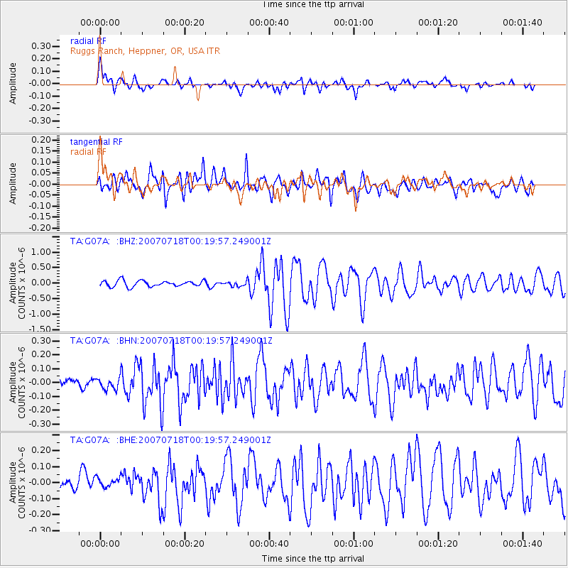
Signal To Noise
| Channel | StoN | STA | LTA |
| TA:G07A: :BHN:20070718T00:19:57.249001Z | 1.1230766 | 4.523454E-8 | 4.0277346E-8 |
| TA:G07A: :BHE:20070718T00:19:57.249001Z | 0.48949906 | 2.9617173E-8 | 6.0505066E-8 |
| TA:G07A: :BHZ:20070718T00:19:57.249001Z | 0.81624603 | 7.823859E-8 | 9.5851725E-8 |
| Arrivals |
| Ps | 2.3 SECOND |
| PpPs | 8.2 SECOND |
| PsPs/PpSs | 11 SECOND |


