You are here: Home > Network List > 4T - Texas Seismological Network (TexNet Stations) Stations List
> Station NM01 Eunice > Earthquake Result Viewer
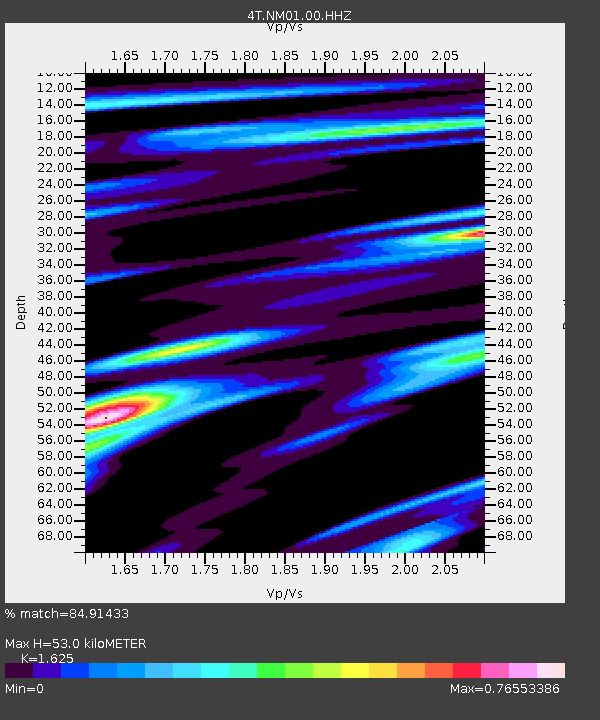
NM01 Eunice - Earthquake Result Viewer
| Earthquake location: |
Tonga Islands |
| Earthquake latitude/longitude: |
-19.4/-174.9 |
| Earthquake time(UTC): |
2019/08/05 (217) 09:01:08 GMT |
| Earthquake Depth: |
10 km |
| Earthquake Magnitude: |
5.7 mb |
| Earthquake Catalog/Contributor: |
NEIC PDE/us |
|
| Network: |
4T Texas Seismological Network (TexNet Stations) |
| Station: |
NM01 Eunice |
| Lat/Lon: |
32.36 N/103.40 W |
| Elevation: |
1051 m |
|
| Distance: |
85.5 deg |
| Az: |
53.611 deg |
| Baz: |
243.903 deg |
| Ray Param: |
0.044716626 |
| Estimated Moho Depth: |
53.0 km |
| Estimated Crust Vp/Vs: |
1.62 |
| Assumed Crust Vp: |
6.129 km/s |
| Estimated Crust Vs: |
3.772 km/s |
| Estimated Crust Poisson's Ratio: |
0.20 |
|
| Radial Match: |
84.91433 % |
| Radial Bump: |
400 |
| Transverse Match: |
76.291595 % |
| Transverse Bump: |
400 |
| SOD ConfigId: |
19053131 |
| Insert Time: |
2019-08-19 09:03:45.172 +0000 |
| GWidth: |
2.5 |
| Max Bumps: |
400 |
| Tol: |
0.001 |
|

Signal To Noise
| Channel | StoN | STA | LTA |
| 4T:NM01:00:HHZ:20190805T09:13:15.059981Z | 16.573982 | 1.3344918E-6 | 8.0517275E-8 |
| 4T:NM01:00:HH1:20190805T09:13:15.059981Z | 1.8415412 | 1.3163204E-7 | 7.147928E-8 |
| 4T:NM01:00:HH2:20190805T09:13:15.059981Z | 5.1452875 | 3.7767938E-7 | 7.340297E-8 |
| Arrivals |
| Ps | 5.5 SECOND |
| PpPs | 22 SECOND |
| PsPs/PpSs | 28 SECOND |


