You are here: Home > Network List > TA - USArray Transportable Network (new EarthScope stations) Stations List
> Station G07A Ruggs Ranch, Heppner, OR, USA > Earthquake Result Viewer
G07A Ruggs Ranch, Heppner, OR, USA - Earthquake Result Viewer
| Earthquake location: |
Solomon Islands |
| Earthquake latitude/longitude: |
-8.5/157.0 |
| Earthquake time(UTC): |
2007/04/01 (091) 20:39:56 GMT |
| Earthquake Depth: |
10 km |
| Earthquake Magnitude: |
6.8 MB, 7.9 MS, 8.1 MW, 7.7 ME |
| Earthquake Catalog/Contributor: |
WHDF/NEIC |
|
| Network: |
TA USArray Transportable Network (new EarthScope stations) |
| Station: |
G07A Ruggs Ranch, Heppner, OR, USA |
| Lat/Lon: |
45.27 N/119.67 W |
| Elevation: |
801 m |
|
| Distance: |
91.2 deg |
| Az: |
44.549 deg |
| Baz: |
259.331 deg |
| Ray Param: |
0.041615464 |
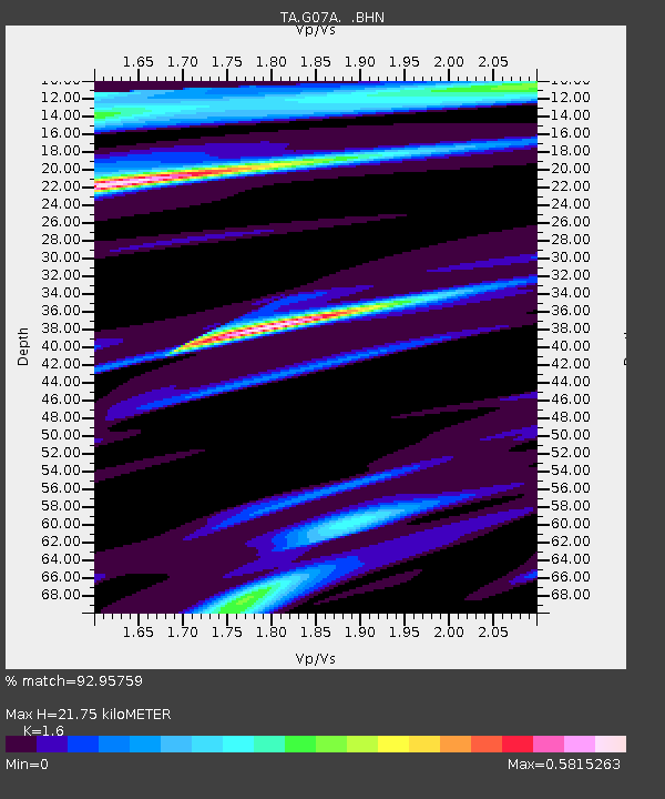
| Estimated Moho Depth: |
21.75 km |
| Estimated Crust Vp/Vs: |
1.60 |
| Assumed Crust Vp: |
6.571 km/s |
| Estimated Crust Vs: |
4.107 km/s |
| Estimated Crust Poisson's Ratio: |
0.18 |
|
| Radial Match: |
92.95759 % |
| Radial Bump: |
360 |
| Transverse Match: |
93.68849 % |
| Transverse Bump: |
400 |
| SOD ConfigId: |
2564 |
| Insert Time: |
2010-03-07 02:49:59.558 +0000 |
| GWidth: |
2.5 |
| Max Bumps: |
400 |
| Tol: |
0.001 |
|
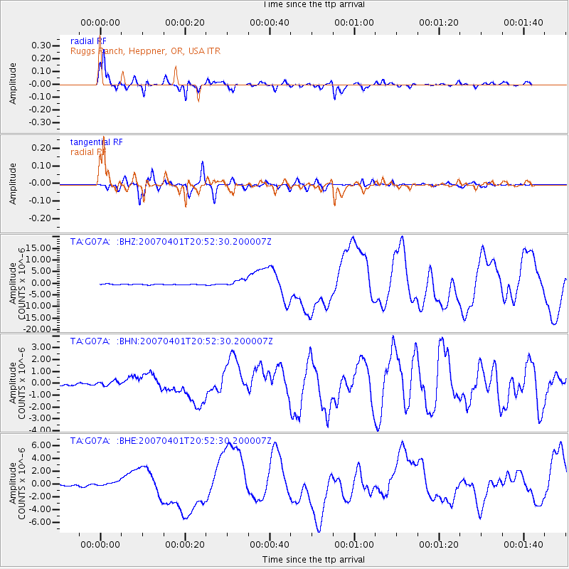
Signal To Noise
| Channel | StoN | STA | LTA |
| TA:G07A: :BHN:20070401T20:52:30.200007Z | 1.703174 | 2.0196984E-7 | 1.1858438E-7 |
| TA:G07A: :BHE:20070401T20:52:30.200007Z | 2.6257377 | 3.929054E-7 | 1.4963621E-7 |
| TA:G07A: :BHZ:20070401T20:52:30.200007Z | 8.286354 | 1.531709E-6 | 1.8484715E-7 |
| Arrivals |
| Ps | 2.0 SECOND |
| PpPs | 8.4 SECOND |
| PsPs/PpSs | 10 SECOND |


