You are here: Home > Network List > TA - USArray Transportable Network (new EarthScope stations) Stations List
> Station G07A Ruggs Ranch, Heppner, OR, USA > Earthquake Result Viewer
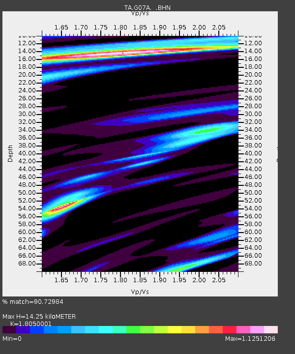
G07A Ruggs Ranch, Heppner, OR, USA - Earthquake Result Viewer
| Earthquake location: |
Andreanof Islands, Aleutian Is. |
| Earthquake latitude/longitude: |
51.9/-179.4 |
| Earthquake time(UTC): |
2008/04/15 (106) 22:59:51 GMT |
| Earthquake Depth: |
10 km |
| Earthquake Magnitude: |
6.1 MB, 6.4 MS, 6.4 MW, 6.4 MW |
| Earthquake Catalog/Contributor: |
WHDF/NEIC |
|
| Network: |
TA USArray Transportable Network (new EarthScope stations) |
| Station: |
G07A Ruggs Ranch, Heppner, OR, USA |
| Lat/Lon: |
45.27 N/119.67 W |
| Elevation: |
801 m |
|
| Distance: |
39.1 deg |
| Az: |
75.333 deg |
| Baz: |
301.826 deg |
| Ray Param: |
0.07520026 |
| Estimated Moho Depth: |
14.25 km |
| Estimated Crust Vp/Vs: |
1.81 |
| Assumed Crust Vp: |
6.571 km/s |
| Estimated Crust Vs: |
3.64 km/s |
| Estimated Crust Poisson's Ratio: |
0.28 |
|
| Radial Match: |
90.72984 % |
| Radial Bump: |
367 |
| Transverse Match: |
77.71359 % |
| Transverse Bump: |
400 |
| SOD ConfigId: |
2504 |
| Insert Time: |
2010-03-07 02:50:14.652 +0000 |
| GWidth: |
2.5 |
| Max Bumps: |
400 |
| Tol: |
0.001 |
|

Signal To Noise
| Channel | StoN | STA | LTA |
| TA:G07A: :BHN:20080415T23:06:47.524011Z | 11.096127 | 1.5280822E-6 | 1.3771312E-7 |
| TA:G07A: :BHE:20080415T23:06:47.524011Z | 1.5263788 | 3.8895956E-7 | 2.5482507E-7 |
| TA:G07A: :BHZ:20080415T23:06:47.524011Z | 2.6259496 | 4.8633035E-7 | 1.8520171E-7 |
| Arrivals |
| Ps | 1.9 SECOND |
| PpPs | 5.7 SECOND |
| PsPs/PpSs | 7.5 SECOND |


