You are here: Home > Network List > TA - USArray Transportable Network (new EarthScope stations) Stations List
> Station G07A Ruggs Ranch, Heppner, OR, USA > Earthquake Result Viewer
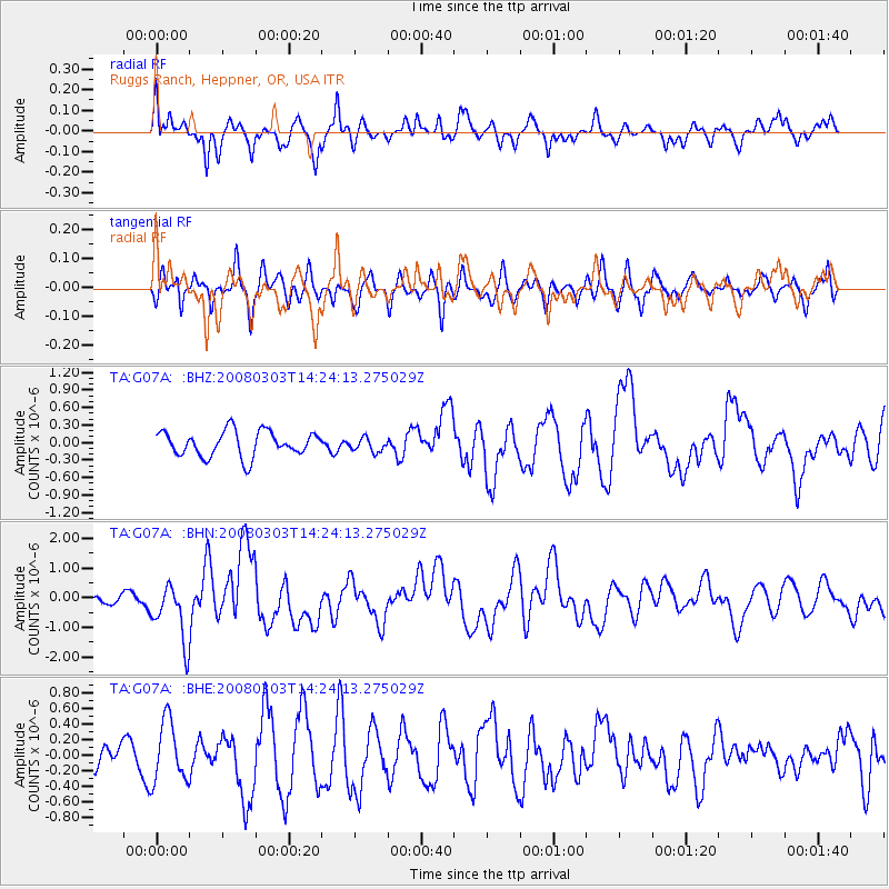
G07A Ruggs Ranch, Heppner, OR, USA - Earthquake Result Viewer
*The percent match for this event was below the threshold and hence no stack was calculated.
| Earthquake location: |
Philippine Islands Region |
| Earthquake latitude/longitude: |
13.4/125.6 |
| Earthquake time(UTC): |
2008/03/03 (063) 14:11:14 GMT |
| Earthquake Depth: |
24 km |
| Earthquake Magnitude: |
6.4 MB, 6.9 MW, 6.8 MW |
| Earthquake Catalog/Contributor: |
WHDF/NEIC |
|
| Network: |
TA USArray Transportable Network (new EarthScope stations) |
| Station: |
G07A Ruggs Ranch, Heppner, OR, USA |
| Lat/Lon: |
45.27 N/119.67 W |
| Elevation: |
801 m |
|
| Distance: |
97.2 deg |
| Az: |
40.288 deg |
| Baz: |
296.972 deg |
| Ray Param: |
$rayparam |
*The percent match for this event was below the threshold and hence was not used in the summary stack. |
|
| Radial Match: |
76.90694 % |
| Radial Bump: |
400 |
| Transverse Match: |
57.619083 % |
| Transverse Bump: |
400 |
| SOD ConfigId: |
2504 |
| Insert Time: |
2010-03-07 02:50:21.065 +0000 |
| GWidth: |
2.5 |
| Max Bumps: |
400 |
| Tol: |
0.001 |
|
Signal To Noise
| Channel | StoN | STA | LTA |
| TA:G07A: :BHN:20080303T14:24:13.275029Z | 2.937196 | 9.799548E-7 | 3.3363617E-7 |
| TA:G07A: :BHE:20080303T14:24:13.275029Z | 2.0185559 | 3.8733637E-7 | 1.9188785E-7 |
| TA:G07A: :BHZ:20080303T14:24:13.275029Z | 0.53872406 | 1.1610612E-7 | 2.1552059E-7 |
| Arrivals |
| Ps | |
| PpPs | |
| PsPs/PpSs | |


