You are here: Home > Network List > TA - USArray Transportable Network (new EarthScope stations) Stations List
> Station G07A Ruggs Ranch, Heppner, OR, USA > Earthquake Result Viewer
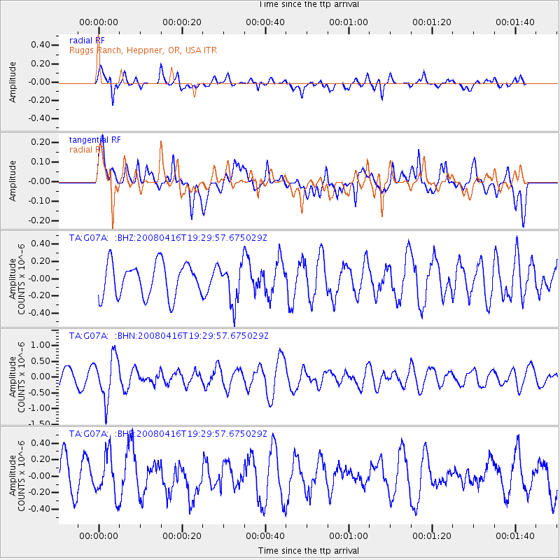
G07A Ruggs Ranch, Heppner, OR, USA - Earthquake Result Viewer
*The percent match for this event was below the threshold and hence no stack was calculated.
| Earthquake location: |
Eastern Honshu, Japan |
| Earthquake latitude/longitude: |
39.0/140.0 |
| Earthquake time(UTC): |
2008/04/16 (107) 19:19:36 GMT |
| Earthquake Depth: |
166 km |
| Earthquake Magnitude: |
5.6 MB, 5.8 MW, 5.8 MW |
| Earthquake Catalog/Contributor: |
WHDF/NEIC |
|
| Network: |
TA USArray Transportable Network (new EarthScope stations) |
| Station: |
G07A Ruggs Ranch, Heppner, OR, USA |
| Lat/Lon: |
45.27 N/119.67 W |
| Elevation: |
801 m |
|
| Distance: |
69.8 deg |
| Az: |
47.759 deg |
| Baz: |
305.259 deg |
| Ray Param: |
$rayparam |
*The percent match for this event was below the threshold and hence was not used in the summary stack. |
|
| Radial Match: |
60.58002 % |
| Radial Bump: |
364 |
| Transverse Match: |
49.383038 % |
| Transverse Bump: |
400 |
| SOD ConfigId: |
2504 |
| Insert Time: |
2010-03-07 02:50:29.607 +0000 |
| GWidth: |
2.5 |
| Max Bumps: |
400 |
| Tol: |
0.001 |
|
Signal To Noise
| Channel | StoN | STA | LTA |
| TA:G07A: :BHN:20080416T19:29:57.675029Z | 3.402338 | 6.8832907E-7 | 2.023106E-7 |
| TA:G07A: :BHE:20080416T19:29:57.675029Z | 1.328391 | 2.555131E-7 | 1.9234783E-7 |
| TA:G07A: :BHZ:20080416T19:29:57.675029Z | 1.1971494 | 2.3068499E-7 | 1.9269525E-7 |
| Arrivals |
| Ps | |
| PpPs | |
| PsPs/PpSs | |


