You are here: Home > Network List > TA - USArray Transportable Network (new EarthScope stations) Stations List
> Station G07A Ruggs Ranch, Heppner, OR, USA > Earthquake Result Viewer
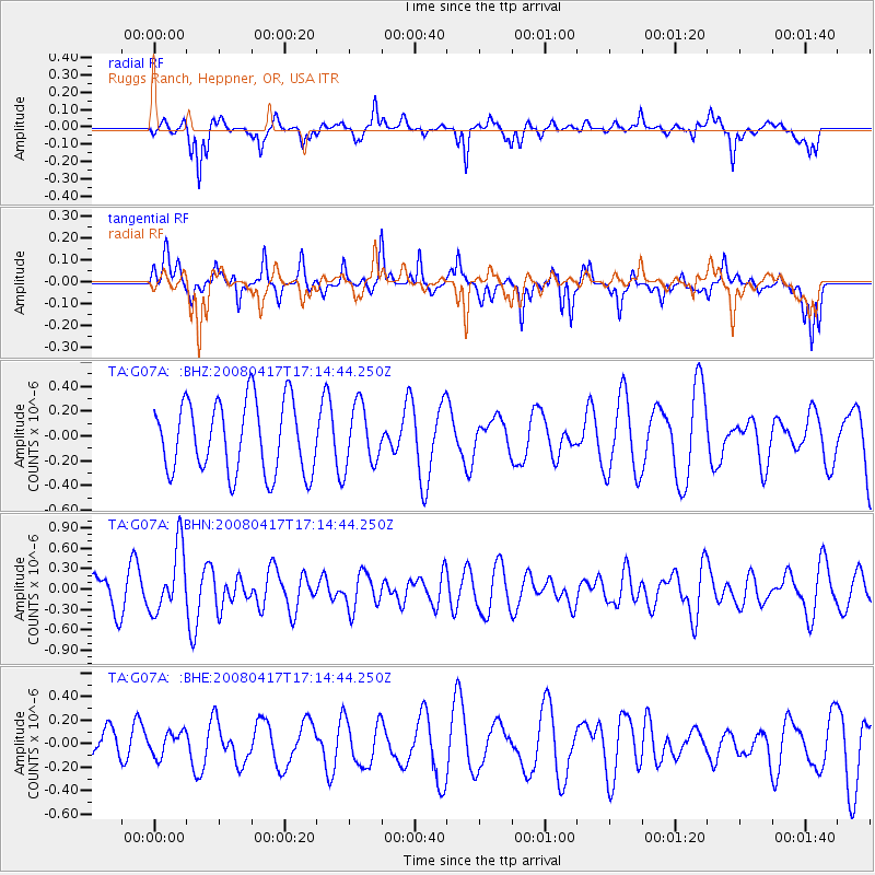
G07A Ruggs Ranch, Heppner, OR, USA - Earthquake Result Viewer
*The percent match for this event was below the threshold and hence no stack was calculated.
| Earthquake location: |
Mariana Islands Region |
| Earthquake latitude/longitude: |
15.9/144.9 |
| Earthquake time(UTC): |
2008/04/17 (108) 17:02:52 GMT |
| Earthquake Depth: |
10 km |
| Earthquake Magnitude: |
5.5 MB, 5.2 MS, 5.5 MW, 5.5 MW |
| Earthquake Catalog/Contributor: |
WHDF/NEIC |
|
| Network: |
TA USArray Transportable Network (new EarthScope stations) |
| Station: |
G07A Ruggs Ranch, Heppner, OR, USA |
| Lat/Lon: |
45.27 N/119.67 W |
| Elevation: |
801 m |
|
| Distance: |
82.6 deg |
| Az: |
45.14 deg |
| Baz: |
285.009 deg |
| Ray Param: |
$rayparam |
*The percent match for this event was below the threshold and hence was not used in the summary stack. |
|
| Radial Match: |
37.350105 % |
| Radial Bump: |
279 |
| Transverse Match: |
55.28802 % |
| Transverse Bump: |
319 |
| SOD ConfigId: |
2504 |
| Insert Time: |
2010-03-07 02:50:31.850 +0000 |
| GWidth: |
2.5 |
| Max Bumps: |
400 |
| Tol: |
0.001 |
|
Signal To Noise
| Channel | StoN | STA | LTA |
| TA:G07A: :BHN:20080417T17:14:44.250Z | 2.2366612 | 4.7686206E-7 | 2.1320263E-7 |
| TA:G07A: :BHE:20080417T17:14:44.250Z | 0.5194717 | 1.07621084E-7 | 2.0717411E-7 |
| TA:G07A: :BHZ:20080417T17:14:44.250Z | 0.8453461 | 2.4275207E-7 | 2.8716295E-7 |
| Arrivals |
| Ps | |
| PpPs | |
| PsPs/PpSs | |


