You are here: Home > Network List > TA - USArray Transportable Network (new EarthScope stations) Stations List
> Station H06A Lindquist Farm, Mitchell, OR, USA > Earthquake Result Viewer
H06A Lindquist Farm, Mitchell, OR, USA - Earthquake Result Viewer
| Earthquake location: |
Near Coast Of Peru |
| Earthquake latitude/longitude: |
-13.6/-76.6 |
| Earthquake time(UTC): |
2007/08/19 (231) 01:22:40 GMT |
| Earthquake Depth: |
26 km |
| Earthquake Magnitude: |
5.9 MB, 5.4 MS, 5.8 MW, 5.5 ML |
| Earthquake Catalog/Contributor: |
WHDF/NEIC |
|
| Network: |
TA USArray Transportable Network (new EarthScope stations) |
| Station: |
H06A Lindquist Farm, Mitchell, OR, USA |
| Lat/Lon: |
44.73 N/120.33 W |
| Elevation: |
516 m |
|
| Distance: |
70.3 deg |
| Az: |
328.459 deg |
| Baz: |
134.476 deg |
| Ray Param: |
0.055019762 |
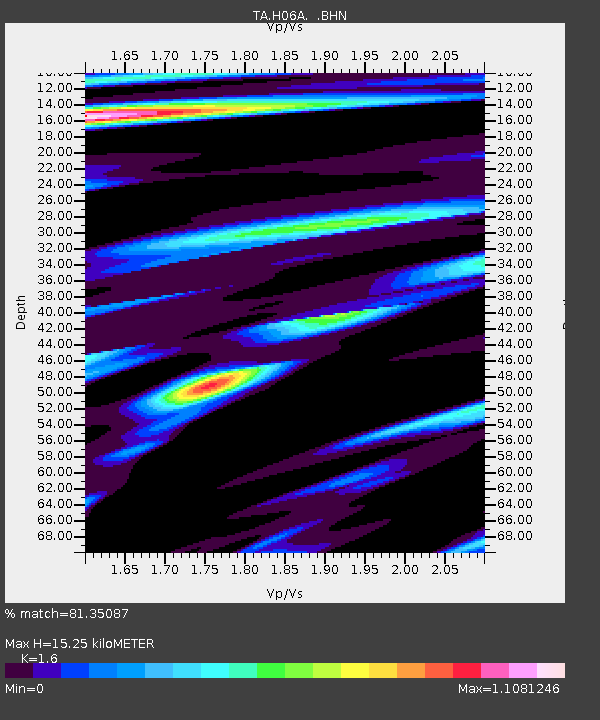
| Estimated Moho Depth: |
15.25 km |
| Estimated Crust Vp/Vs: |
1.60 |
| Assumed Crust Vp: |
6.597 km/s |
| Estimated Crust Vs: |
4.123 km/s |
| Estimated Crust Poisson's Ratio: |
0.18 |
|
| Radial Match: |
81.35087 % |
| Radial Bump: |
400 |
| Transverse Match: |
75.13542 % |
| Transverse Bump: |
400 |
| SOD ConfigId: |
2564 |
| Insert Time: |
2010-03-07 02:50:56.405 +0000 |
| GWidth: |
2.5 |
| Max Bumps: |
400 |
| Tol: |
0.001 |
|

Signal To Noise
| Channel | StoN | STA | LTA |
| TA:H06A: :BHN:20070819T01:33:20.800015Z | 1.7362144 | 1.3067603E-7 | 7.5264914E-8 |
| TA:H06A: :BHE:20070819T01:33:20.800015Z | 1.2331681 | 9.3592625E-8 | 7.589608E-8 |
| TA:H06A: :BHZ:20070819T01:33:20.800015Z | 7.319001 | 3.8012138E-7 | 5.1936237E-8 |
| Arrivals |
| Ps | 1.4 SECOND |
| PpPs | 5.8 SECOND |
| PsPs/PpSs | 7.2 SECOND |


