You are here: Home > Network List > CI - Caltech Regional Seismic Network Stations List
> Station MUR Murrieta > Earthquake Result Viewer
MUR Murrieta - Earthquake Result Viewer
| Earthquake location: |
Tonga Islands |
| Earthquake latitude/longitude: |
-19.4/-174.9 |
| Earthquake time(UTC): |
2019/08/05 (217) 09:01:08 GMT |
| Earthquake Depth: |
10 km |
| Earthquake Magnitude: |
5.7 mb |
| Earthquake Catalog/Contributor: |
NEIC PDE/us |
|
| Network: |
CI Caltech Regional Seismic Network |
| Station: |
MUR Murrieta |
| Lat/Lon: |
33.60 N/117.20 W |
| Elevation: |
562 m |
|
| Distance: |
76.1 deg |
| Az: |
46.598 deg |
| Baz: |
235.278 deg |
| Ray Param: |
0.051206253 |
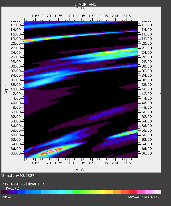
| Estimated Moho Depth: |
66.75 km |
| Estimated Crust Vp/Vs: |
1.72 |
| Assumed Crust Vp: |
6.264 km/s |
| Estimated Crust Vs: |
3.642 km/s |
| Estimated Crust Poisson's Ratio: |
0.24 |
|
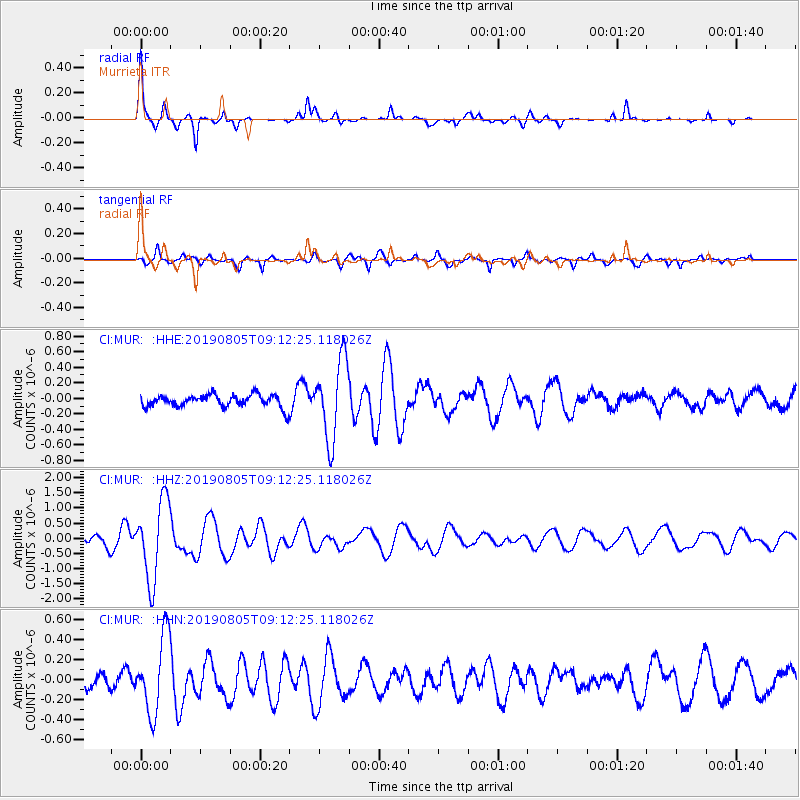
| Radial Match: |
93.08274 % |
| Radial Bump: |
217 |
| Transverse Match: |
83.11657 % |
| Transverse Bump: |
365 |
| SOD ConfigId: |
19053131 |
| Insert Time: |
2019-08-19 09:06:53.606 +0000 |
| GWidth: |
2.5 |
| Max Bumps: |
400 |
| Tol: |
0.001 |
|
Signal To Noise
| Channel | StoN | STA | LTA |
| CI:MUR: :HHZ:20190805T09:12:25.118026Z | 11.154509 | 1.3036431E-6 | 1.16871405E-7 |
| CI:MUR: :HHN:20190805T09:12:25.118026Z | 4.875979 | 3.8557124E-7 | 7.9075654E-8 |
| CI:MUR: :HHE:20190805T09:12:25.118026Z | 6.418834 | 5.073336E-7 | 7.903827E-8 |
| Arrivals |
| Ps | 7.9 SECOND |
| PpPs | 28 SECOND |
| PsPs/PpSs | 36 SECOND |


