You are here: Home > Network List > TA - USArray Transportable Network (new EarthScope stations) Stations List
> Station H06A Lindquist Farm, Mitchell, OR, USA > Earthquake Result Viewer
H06A Lindquist Farm, Mitchell, OR, USA - Earthquake Result Viewer
| Earthquake location: |
Vanuatu Islands |
| Earthquake latitude/longitude: |
-15.6/167.7 |
| Earthquake time(UTC): |
2007/08/01 (213) 17:08:51 GMT |
| Earthquake Depth: |
120 km |
| Earthquake Magnitude: |
6.2 MB, 7.2 MW, 7.2 MW |
| Earthquake Catalog/Contributor: |
WHDF/NEIC |
|
| Network: |
TA USArray Transportable Network (new EarthScope stations) |
| Station: |
H06A Lindquist Farm, Mitchell, OR, USA |
| Lat/Lon: |
44.73 N/120.33 W |
| Elevation: |
516 m |
|
| Distance: |
88.6 deg |
| Az: |
42.688 deg |
| Baz: |
246.448 deg |
| Ray Param: |
0.042233538 |
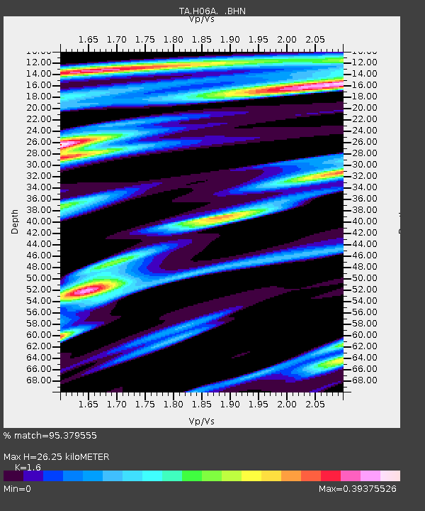
| Estimated Moho Depth: |
26.25 km |
| Estimated Crust Vp/Vs: |
1.60 |
| Assumed Crust Vp: |
6.597 km/s |
| Estimated Crust Vs: |
4.123 km/s |
| Estimated Crust Poisson's Ratio: |
0.18 |
|
| Radial Match: |
95.379555 % |
| Radial Bump: |
400 |
| Transverse Match: |
88.09537 % |
| Transverse Bump: |
400 |
| SOD ConfigId: |
2564 |
| Insert Time: |
2010-03-07 02:51:42.078 +0000 |
| GWidth: |
2.5 |
| Max Bumps: |
400 |
| Tol: |
0.001 |
|

Signal To Noise
| Channel | StoN | STA | LTA |
| TA:H06A: :BHN:20070801T17:20:59.475012Z | 1.2999854 | 1.00878154E-7 | 7.759945E-8 |
| TA:H06A: :BHE:20070801T17:20:59.475012Z | 4.6235113 | 2.4878423E-7 | 5.3808503E-8 |
| TA:H06A: :BHZ:20070801T17:20:59.475012Z | 8.288023 | 9.612595E-7 | 1.15981756E-7 |
| Arrivals |
| Ps | 2.4 SECOND |
| PpPs | 10 SECOND |
| PsPs/PpSs | 13 SECOND |


