You are here: Home > Network List > TA - USArray Transportable Network (new EarthScope stations) Stations List
> Station H06A Lindquist Farm, Mitchell, OR, USA > Earthquake Result Viewer
H06A Lindquist Farm, Mitchell, OR, USA - Earthquake Result Viewer
| Earthquake location: |
Near West Coast Of Honshu, Japan |
| Earthquake latitude/longitude: |
37.5/138.4 |
| Earthquake time(UTC): |
2007/07/16 (197) 01:13:22 GMT |
| Earthquake Depth: |
12 km |
| Earthquake Magnitude: |
6.5 MB, 6.4 MS, 6.6 MW, 6.5 MW |
| Earthquake Catalog/Contributor: |
WHDF/NEIC |
|
| Network: |
TA USArray Transportable Network (new EarthScope stations) |
| Station: |
H06A Lindquist Farm, Mitchell, OR, USA |
| Lat/Lon: |
44.73 N/120.33 W |
| Elevation: |
516 m |
|
| Distance: |
71.6 deg |
| Az: |
47.45 deg |
| Baz: |
304.747 deg |
| Ray Param: |
0.054201897 |
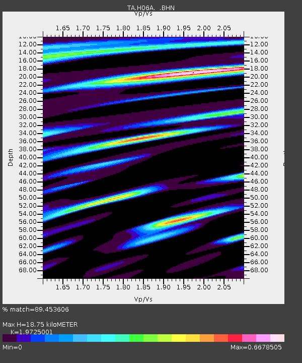
| Estimated Moho Depth: |
18.75 km |
| Estimated Crust Vp/Vs: |
1.97 |
| Assumed Crust Vp: |
6.597 km/s |
| Estimated Crust Vs: |
3.345 km/s |
| Estimated Crust Poisson's Ratio: |
0.33 |
|
| Radial Match: |
89.453606 % |
| Radial Bump: |
400 |
| Transverse Match: |
89.96805 % |
| Transverse Bump: |
400 |
| SOD ConfigId: |
2564 |
| Insert Time: |
2010-03-07 02:51:46.734 +0000 |
| GWidth: |
2.5 |
| Max Bumps: |
400 |
| Tol: |
0.001 |
|

Signal To Noise
| Channel | StoN | STA | LTA |
| TA:H06A: :BHN:20070716T01:24:12.325017Z | 9.783606 | 4.5340616E-7 | 4.6343466E-8 |
| TA:H06A: :BHE:20070716T01:24:12.325017Z | 7.581959 | 5.0545424E-7 | 6.6665386E-8 |
| TA:H06A: :BHZ:20070716T01:24:12.325017Z | 31.922596 | 1.9651577E-6 | 6.156009E-8 |
| Arrivals |
| Ps | 2.9 SECOND |
| PpPs | 8.2 SECOND |
| PsPs/PpSs | 11 SECOND |


