You are here: Home > Network List > NN - Western Great Basin/Eastern Sierra Nevada Stations List
> Station PAH Pah Rah Range, Nevada w84gm > Earthquake Result Viewer
PAH Pah Rah Range, Nevada w84gm - Earthquake Result Viewer
| Earthquake location: |
Tonga Islands |
| Earthquake latitude/longitude: |
-19.4/-174.9 |
| Earthquake time(UTC): |
2019/08/05 (217) 09:01:08 GMT |
| Earthquake Depth: |
10 km |
| Earthquake Magnitude: |
5.7 mb |
| Earthquake Catalog/Contributor: |
NEIC PDE/us |
|
| Network: |
NN Western Great Basin/Eastern Sierra Nevada |
| Station: |
PAH Pah Rah Range, Nevada w84gm |
| Lat/Lon: |
39.71 N/119.39 W |
| Elevation: |
1520 m |
|
| Distance: |
78.3 deg |
| Az: |
40.48 deg |
| Baz: |
232.618 deg |
| Ray Param: |
0.049742848 |
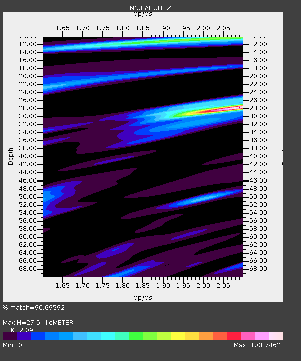
| Estimated Moho Depth: |
27.5 km |
| Estimated Crust Vp/Vs: |
2.09 |
| Assumed Crust Vp: |
6.279 km/s |
| Estimated Crust Vs: |
3.004 km/s |
| Estimated Crust Poisson's Ratio: |
0.35 |
|
| Radial Match: |
90.69592 % |
| Radial Bump: |
314 |
| Transverse Match: |
85.621414 % |
| Transverse Bump: |
400 |
| SOD ConfigId: |
19053131 |
| Insert Time: |
2019-08-19 09:09:31.369 +0000 |
| GWidth: |
2.5 |
| Max Bumps: |
400 |
| Tol: |
0.001 |
|

Signal To Noise
| Channel | StoN | STA | LTA |
| NN:PAH: :HHZ:20190805T09:12:37.239974Z | 10.545657 | 1.3299757E-6 | 1.2611595E-7 |
| NN:PAH: :HHN:20190805T09:12:37.239974Z | 7.5991206 | 3.3110234E-7 | 4.3571138E-8 |
| NN:PAH: :HHE:20190805T09:12:37.239974Z | 3.593516 | 2.3902754E-7 | 6.651634E-8 |
| Arrivals |
| Ps | 4.9 SECOND |
| PpPs | 13 SECOND |
| PsPs/PpSs | 18 SECOND |


