You are here: Home > Network List > NN - Western Great Basin/Eastern Sierra Nevada Stations List
> Station R11B Troy Canyon, Currant, NV, USA > Earthquake Result Viewer
R11B Troy Canyon, Currant, NV, USA - Earthquake Result Viewer
| Earthquake location: |
Tonga Islands |
| Earthquake latitude/longitude: |
-19.4/-174.9 |
| Earthquake time(UTC): |
2019/08/05 (217) 09:01:08 GMT |
| Earthquake Depth: |
10 km |
| Earthquake Magnitude: |
5.7 mb |
| Earthquake Catalog/Contributor: |
NEIC PDE/us |
|
| Network: |
NN Western Great Basin/Eastern Sierra Nevada |
| Station: |
R11B Troy Canyon, Currant, NV, USA |
| Lat/Lon: |
38.35 N/115.59 W |
| Elevation: |
1767 m |
|
| Distance: |
79.9 deg |
| Az: |
43.369 deg |
| Baz: |
235.549 deg |
| Ray Param: |
0.048651718 |
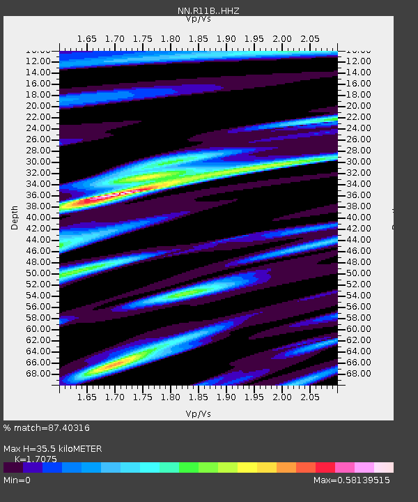
| Estimated Moho Depth: |
35.5 km |
| Estimated Crust Vp/Vs: |
1.71 |
| Assumed Crust Vp: |
6.276 km/s |
| Estimated Crust Vs: |
3.675 km/s |
| Estimated Crust Poisson's Ratio: |
0.24 |
|
| Radial Match: |
87.40316 % |
| Radial Bump: |
347 |
| Transverse Match: |
79.31103 % |
| Transverse Bump: |
400 |
| SOD ConfigId: |
19053131 |
| Insert Time: |
2019-08-19 09:09:34.682 +0000 |
| GWidth: |
2.5 |
| Max Bumps: |
400 |
| Tol: |
0.001 |
|

Signal To Noise
| Channel | StoN | STA | LTA |
| NN:R11B: :HHZ:20190805T09:12:45.970016Z | 10.617924 | 9.265863E-7 | 8.7266244E-8 |
| NN:R11B: :HHN:20190805T09:12:45.970016Z | 4.6506333 | 2.0454777E-7 | 4.398278E-8 |
| NN:R11B: :HHE:20190805T09:12:45.970016Z | 8.220577 | 3.4090934E-7 | 4.1470248E-8 |
| Arrivals |
| Ps | 4.1 SECOND |
| PpPs | 15 SECOND |
| PsPs/PpSs | 19 SECOND |


