You are here: Home > Network List > TA - USArray Transportable Network (new EarthScope stations) Stations List
> Station H06A Lindquist Farm, Mitchell, OR, USA > Earthquake Result Viewer
H06A Lindquist Farm, Mitchell, OR, USA - Earthquake Result Viewer
| Earthquake location: |
Kuril Islands |
| Earthquake latitude/longitude: |
46.4/153.2 |
| Earthquake time(UTC): |
2008/03/03 (063) 09:31:02 GMT |
| Earthquake Depth: |
10 km |
| Earthquake Magnitude: |
6.2 MB, 6.5 MS, 6.5 MW, 6.5 MW |
| Earthquake Catalog/Contributor: |
WHDF/NEIC |
|
| Network: |
TA USArray Transportable Network (new EarthScope stations) |
| Station: |
H06A Lindquist Farm, Mitchell, OR, USA |
| Lat/Lon: |
44.73 N/120.33 W |
| Elevation: |
516 m |
|
| Distance: |
57.5 deg |
| Az: |
57.462 deg |
| Baz: |
305.068 deg |
| Ray Param: |
0.06341981 |
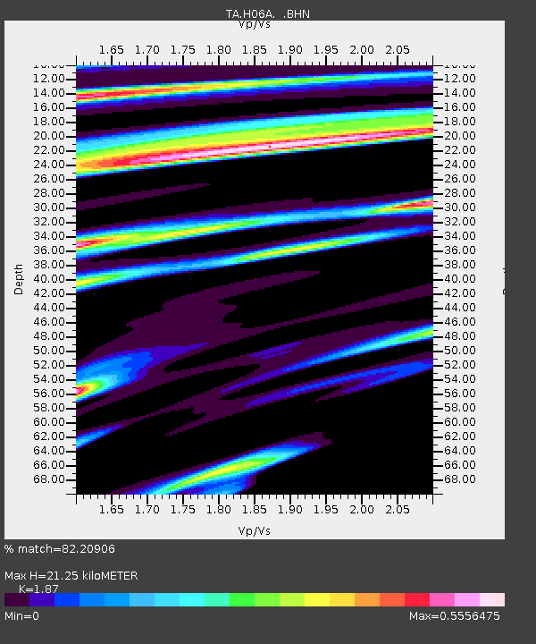
| Estimated Moho Depth: |
21.25 km |
| Estimated Crust Vp/Vs: |
1.87 |
| Assumed Crust Vp: |
6.597 km/s |
| Estimated Crust Vs: |
3.528 km/s |
| Estimated Crust Poisson's Ratio: |
0.30 |
|
| Radial Match: |
82.20906 % |
| Radial Bump: |
377 |
| Transverse Match: |
78.296196 % |
| Transverse Bump: |
400 |
| SOD ConfigId: |
2564 |
| Insert Time: |
2010-03-07 02:52:07.501 +0000 |
| GWidth: |
2.5 |
| Max Bumps: |
400 |
| Tol: |
0.001 |
|

Signal To Noise
| Channel | StoN | STA | LTA |
| TA:H06A: :BHN:20080303T09:40:21.025024Z | 1.0487896 | 2.437175E-7 | 2.3237979E-7 |
| TA:H06A: :BHE:20080303T09:40:21.025024Z | 0.7980104 | 2.0342617E-7 | 2.5491667E-7 |
| TA:H06A: :BHZ:20080303T09:40:21.025024Z | 3.2936578 | 4.8482514E-7 | 1.471996E-7 |
| Arrivals |
| Ps | 2.9 SECOND |
| PpPs | 8.8 SECOND |
| PsPs/PpSs | 12 SECOND |


