You are here: Home > Network List > O2 - Oklahoma Consolidated Temporary Seismic Networks Stations List
> Station FW06 Aline, Oklahoma, USA > Earthquake Result Viewer
FW06 Aline, Oklahoma, USA - Earthquake Result Viewer
| Earthquake location: |
Tonga Islands |
| Earthquake latitude/longitude: |
-19.4/-174.9 |
| Earthquake time(UTC): |
2019/08/05 (217) 09:01:08 GMT |
| Earthquake Depth: |
10 km |
| Earthquake Magnitude: |
5.7 mb |
| Earthquake Catalog/Contributor: |
NEIC PDE/us |
|
| Network: |
O2 Oklahoma Consolidated Temporary Seismic Networks |
| Station: |
FW06 Aline, Oklahoma, USA |
| Lat/Lon: |
36.51 N/98.50 W |
| Elevation: |
420 m |
|
| Distance: |
90.9 deg |
| Az: |
51.542 deg |
| Baz: |
246.599 deg |
| Ray Param: |
0.041639093 |
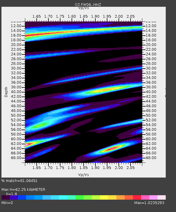
| Estimated Moho Depth: |
62.25 km |
| Estimated Crust Vp/Vs: |
1.60 |
| Assumed Crust Vp: |
6.426 km/s |
| Estimated Crust Vs: |
4.016 km/s |
| Estimated Crust Poisson's Ratio: |
0.18 |
|
| Radial Match: |
81.06451 % |
| Radial Bump: |
400 |
| Transverse Match: |
61.30391 % |
| Transverse Bump: |
400 |
| SOD ConfigId: |
19053131 |
| Insert Time: |
2019-08-19 09:09:56.984 +0000 |
| GWidth: |
2.5 |
| Max Bumps: |
400 |
| Tol: |
0.001 |
|

Signal To Noise
| Channel | StoN | STA | LTA |
| O2:FW06: :HHZ:20190805T09:13:40.824996Z | 9.219322 | 6.897448E-7 | 7.4815134E-8 |
| O2:FW06: :HHN:20190805T09:13:40.824996Z | 1.7311164 | 1.3044347E-7 | 7.5352226E-8 |
| O2:FW06: :HHE:20190805T09:13:40.824996Z | 2.2574728 | 1.8082885E-7 | 8.010233E-8 |
| Arrivals |
| Ps | 5.9 SECOND |
| PpPs | 25 SECOND |
| PsPs/PpSs | 31 SECOND |


