You are here: Home > Network List > TA - USArray Transportable Network (new EarthScope stations) Stations List
> Station H06A Lindquist Farm, Mitchell, OR, USA > Earthquake Result Viewer
H06A Lindquist Farm, Mitchell, OR, USA - Earthquake Result Viewer
| Earthquake location: |
Vanuatu Islands |
| Earthquake latitude/longitude: |
-19.9/169.0 |
| Earthquake time(UTC): |
2008/04/28 (119) 18:33:34 GMT |
| Earthquake Depth: |
32 km |
| Earthquake Magnitude: |
6.2 MB, 6.2 MS, 6.4 MW, 6.4 MW |
| Earthquake Catalog/Contributor: |
WHDF/NEIC |
|
| Network: |
TA USArray Transportable Network (new EarthScope stations) |
| Station: |
H06A Lindquist Farm, Mitchell, OR, USA |
| Lat/Lon: |
44.73 N/120.33 W |
| Elevation: |
516 m |
|
| Distance: |
90.9 deg |
| Az: |
42.285 deg |
| Baz: |
242.634 deg |
| Ray Param: |
0.041634105 |
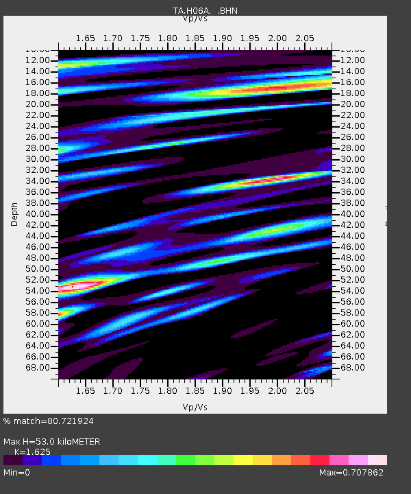
| Estimated Moho Depth: |
53.0 km |
| Estimated Crust Vp/Vs: |
1.62 |
| Assumed Crust Vp: |
6.597 km/s |
| Estimated Crust Vs: |
4.06 km/s |
| Estimated Crust Poisson's Ratio: |
0.20 |
|
| Radial Match: |
80.721924 % |
| Radial Bump: |
400 |
| Transverse Match: |
75.21177 % |
| Transverse Bump: |
400 |
| SOD ConfigId: |
2504 |
| Insert Time: |
2010-03-07 02:52:16.905 +0000 |
| GWidth: |
2.5 |
| Max Bumps: |
400 |
| Tol: |
0.001 |
|

Signal To Noise
| Channel | StoN | STA | LTA |
| TA:H06A: :BHN:20080428T18:46:03.499011Z | 15.594278 | 2.6004961E-6 | 1.6675963E-7 |
| TA:H06A: :BHE:20080428T18:46:03.499011Z | 4.7088165 | 4.628107E-7 | 9.828599E-8 |
| TA:H06A: :BHZ:20080428T18:46:03.499011Z | 5.5159507 | 7.039271E-7 | 1.2761664E-7 |
| Arrivals |
| Ps | 5.1 SECOND |
| PpPs | 21 SECOND |
| PsPs/PpSs | 26 SECOND |


