You are here: Home > Network List > TA - USArray Transportable Network (new EarthScope stations) Stations List
> Station H06A Lindquist Farm, Mitchell, OR, USA > Earthquake Result Viewer
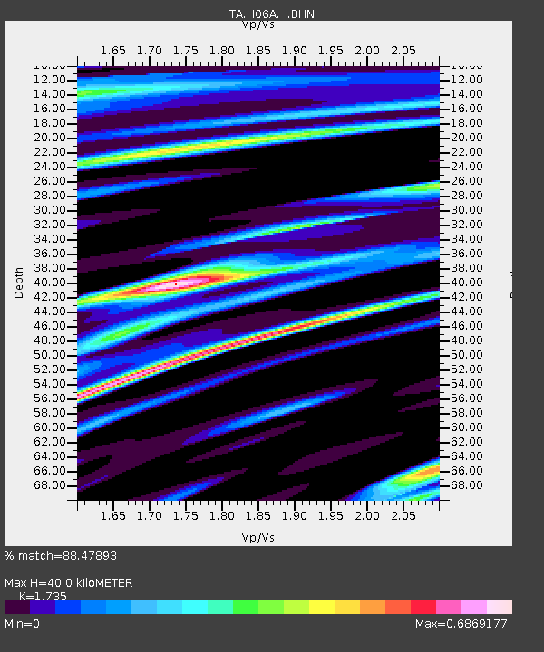
H06A Lindquist Farm, Mitchell, OR, USA - Earthquake Result Viewer
| Earthquake location: |
Andreanof Islands, Aleutian Is. |
| Earthquake latitude/longitude: |
51.9/-177.5 |
| Earthquake time(UTC): |
2008/05/02 (123) 01:33:37 GMT |
| Earthquake Depth: |
14 km |
| Earthquake Magnitude: |
6.3 MB, 6.8 MS, 6.6 MW, 6.6 MW |
| Earthquake Catalog/Contributor: |
WHDF/NEIC |
|
| Network: |
TA USArray Transportable Network (new EarthScope stations) |
| Station: |
H06A Lindquist Farm, Mitchell, OR, USA |
| Lat/Lon: |
44.73 N/120.33 W |
| Elevation: |
516 m |
|
| Distance: |
37.8 deg |
| Az: |
77.574 deg |
| Baz: |
301.828 deg |
| Ray Param: |
0.07589905 |
| Estimated Moho Depth: |
40.0 km |
| Estimated Crust Vp/Vs: |
1.74 |
| Assumed Crust Vp: |
6.597 km/s |
| Estimated Crust Vs: |
3.803 km/s |
| Estimated Crust Poisson's Ratio: |
0.25 |
|
| Radial Match: |
88.47893 % |
| Radial Bump: |
379 |
| Transverse Match: |
74.741905 % |
| Transverse Bump: |
400 |
| SOD ConfigId: |
2504 |
| Insert Time: |
2010-03-07 02:52:18.724 +0000 |
| GWidth: |
2.5 |
| Max Bumps: |
400 |
| Tol: |
0.001 |
|

Signal To Noise
| Channel | StoN | STA | LTA |
| TA:H06A: :BHN:20080502T01:40:22.50001Z | 22.075476 | 1.5669658E-6 | 7.0982196E-8 |
| TA:H06A: :BHE:20080502T01:40:22.50001Z | 3.8249872 | 5.686712E-7 | 1.4867271E-7 |
| TA:H06A: :BHZ:20080502T01:40:22.50001Z | 3.7839346 | 5.842693E-7 | 1.5440787E-7 |
| Arrivals |
| Ps | 4.8 SECOND |
| PpPs | 15 SECOND |
| PsPs/PpSs | 20 SECOND |


