You are here: Home > Network List > G - GEOSCOPE Stations List
> Station CLF Chambon la Foret observatory, France > Earthquake Result Viewer
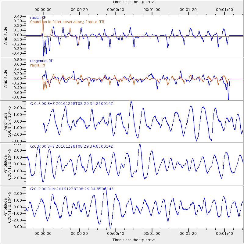
CLF Chambon la Foret observatory, France - Earthquake Result Viewer
*The percent match for this event was below the threshold and hence no stack was calculated.
| Earthquake location: |
California-Nevada Border Region |
| Earthquake latitude/longitude: |
38.4/-118.9 |
| Earthquake time(UTC): |
2016/12/28 (363) 08:18:00 GMT |
| Earthquake Depth: |
11 km |
| Earthquake Magnitude: |
5.8 ML |
| Earthquake Catalog/Contributor: |
NEIC PDE/nn |
|
| Network: |
G GEOSCOPE |
| Station: |
CLF Chambon la Foret observatory, France |
| Lat/Lon: |
48.03 N/2.26 E |
| Elevation: |
145 m |
|
| Distance: |
79.3 deg |
| Az: |
35.772 deg |
| Baz: |
316.807 deg |
| Ray Param: |
$rayparam |
*The percent match for this event was below the threshold and hence was not used in the summary stack. |
|
| Radial Match: |
80.863235 % |
| Radial Bump: |
392 |
| Transverse Match: |
62.023544 % |
| Transverse Bump: |
400 |
| SOD ConfigId: |
1943534 |
| Insert Time: |
2017-01-11 08:18:53.622 +0000 |
| GWidth: |
2.5 |
| Max Bumps: |
400 |
| Tol: |
0.001 |
|
Signal To Noise
| Channel | StoN | STA | LTA |
| G:CLF:00:BHZ:20161228T08:29:34.850014Z | 2.3368664 | 1.6857717E-6 | 7.2138124E-7 |
| G:CLF:00:BHN:20161228T08:29:34.850014Z | 0.9026704 | 1.1923398E-6 | 1.3209028E-6 |
| G:CLF:00:BHE:20161228T08:29:34.850014Z | 0.43065593 | 4.245157E-7 | 9.857421E-7 |
| Arrivals |
| Ps | |
| PpPs | |
| PsPs/PpSs | |


