You are here: Home > Network List > TA - USArray Transportable Network (new EarthScope stations) Stations List
> Station J25K Salcha River, AK, USA > Earthquake Result Viewer
J25K Salcha River, AK, USA - Earthquake Result Viewer
| Earthquake location: |
Tonga Islands |
| Earthquake latitude/longitude: |
-19.4/-174.9 |
| Earthquake time(UTC): |
2019/08/05 (217) 09:01:08 GMT |
| Earthquake Depth: |
10 km |
| Earthquake Magnitude: |
5.7 mb |
| Earthquake Catalog/Contributor: |
NEIC PDE/us |
|
| Network: |
TA USArray Transportable Network (new EarthScope stations) |
| Station: |
J25K Salcha River, AK, USA |
| Lat/Lon: |
64.61 N/145.37 W |
| Elevation: |
949 m |
|
| Distance: |
86.7 deg |
| Az: |
12.279 deg |
| Baz: |
207.764 deg |
| Ray Param: |
0.043836895 |
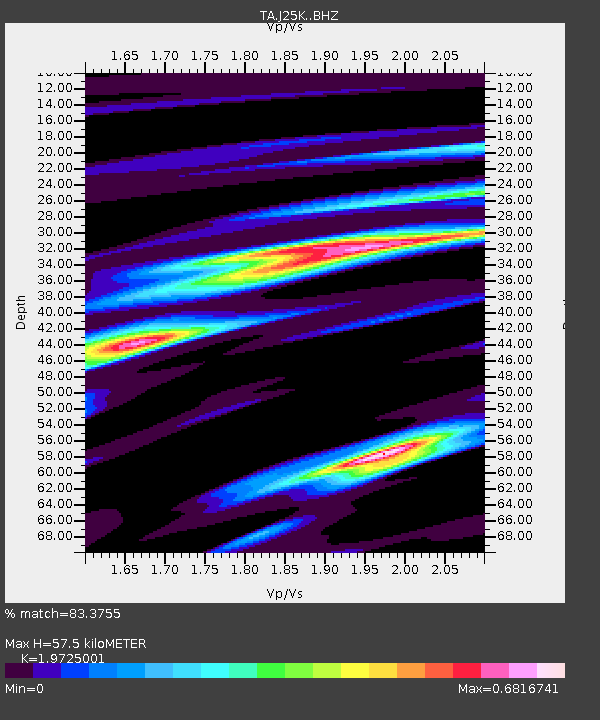
| Estimated Moho Depth: |
57.5 km |
| Estimated Crust Vp/Vs: |
1.97 |
| Assumed Crust Vp: |
6.566 km/s |
| Estimated Crust Vs: |
3.329 km/s |
| Estimated Crust Poisson's Ratio: |
0.33 |
|
| Radial Match: |
83.3755 % |
| Radial Bump: |
400 |
| Transverse Match: |
78.61533 % |
| Transverse Bump: |
400 |
| SOD ConfigId: |
19053131 |
| Insert Time: |
2019-08-19 09:12:05.701 +0000 |
| GWidth: |
2.5 |
| Max Bumps: |
400 |
| Tol: |
0.001 |
|
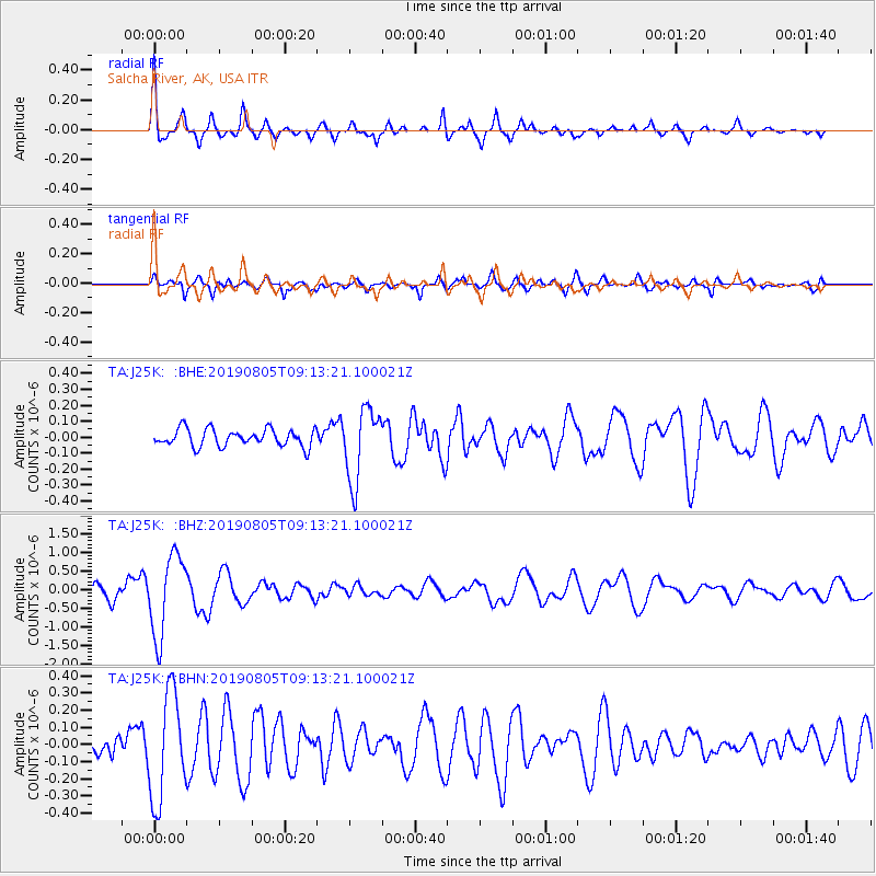
Signal To Noise
| Channel | StoN | STA | LTA |
| TA:J25K: :BHZ:20190805T09:13:21.100021Z | 8.697331 | 1.0868861E-6 | 1.2496776E-7 |
| TA:J25K: :BHN:20190805T09:13:21.100021Z | 5.540745 | 3.1323418E-7 | 5.653287E-8 |
| TA:J25K: :BHE:20190805T09:13:21.100021Z | 4.2508655 | 2.280453E-7 | 5.3646794E-8 |
| Arrivals |
| Ps | 8.7 SECOND |
| PpPs | 25 SECOND |
| PsPs/PpSs | 34 SECOND |


