You are here: Home > Network List > TA - USArray Transportable Network (new EarthScope stations) Stations List
> Station K20K Telida, AK, USA > Earthquake Result Viewer
K20K Telida, AK, USA - Earthquake Result Viewer
| Earthquake location: |
Tonga Islands |
| Earthquake latitude/longitude: |
-19.4/-174.9 |
| Earthquake time(UTC): |
2019/08/05 (217) 09:01:08 GMT |
| Earthquake Depth: |
10 km |
| Earthquake Magnitude: |
5.7 mb |
| Earthquake Catalog/Contributor: |
NEIC PDE/us |
|
| Network: |
TA USArray Transportable Network (new EarthScope stations) |
| Station: |
K20K Telida, AK, USA |
| Lat/Lon: |
63.36 N/154.07 W |
| Elevation: |
548 m |
|
| Distance: |
84.0 deg |
| Az: |
9.267 deg |
| Baz: |
199.709 deg |
| Ray Param: |
0.045761835 |
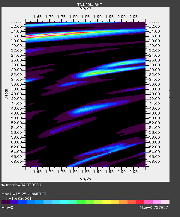
| Estimated Moho Depth: |
15.25 km |
| Estimated Crust Vp/Vs: |
1.69 |
| Assumed Crust Vp: |
6.438 km/s |
| Estimated Crust Vs: |
3.821 km/s |
| Estimated Crust Poisson's Ratio: |
0.23 |
|
| Radial Match: |
84.073906 % |
| Radial Bump: |
352 |
| Transverse Match: |
69.25781 % |
| Transverse Bump: |
375 |
| SOD ConfigId: |
19053131 |
| Insert Time: |
2019-08-19 09:12:09.329 +0000 |
| GWidth: |
2.5 |
| Max Bumps: |
400 |
| Tol: |
0.001 |
|

Signal To Noise
| Channel | StoN | STA | LTA |
| TA:K20K: :BHZ:20190805T09:13:07.699996Z | 8.446291 | 1.3113043E-6 | 1.5525211E-7 |
| TA:K20K: :BHN:20190805T09:13:07.699996Z | 2.72535 | 2.966966E-7 | 1.0886551E-7 |
| TA:K20K: :BHE:20190805T09:13:07.699996Z | 1.2141056 | 1.2759106E-7 | 1.0509058E-7 |
| Arrivals |
| Ps | 1.7 SECOND |
| PpPs | 6.2 SECOND |
| PsPs/PpSs | 7.9 SECOND |


