You are here: Home > Network List > TA - USArray Transportable Network (new EarthScope stations) Stations List
> Station L15K Ungalak Mountain, AK, USA > Earthquake Result Viewer
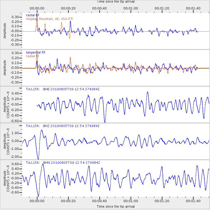
L15K Ungalak Mountain, AK, USA - Earthquake Result Viewer
*The percent match for this event was below the threshold and hence no stack was calculated.
| Earthquake location: |
Tonga Islands |
| Earthquake latitude/longitude: |
-19.4/-174.9 |
| Earthquake time(UTC): |
2019/08/05 (217) 09:01:08 GMT |
| Earthquake Depth: |
10 km |
| Earthquake Magnitude: |
5.7 mb |
| Earthquake Catalog/Contributor: |
NEIC PDE/us |
|
| Network: |
TA USArray Transportable Network (new EarthScope stations) |
| Station: |
L15K Ungalak Mountain, AK, USA |
| Lat/Lon: |
61.68 N/161.49 W |
| Elevation: |
219 m |
|
| Distance: |
81.5 deg |
| Az: |
6.413 deg |
| Baz: |
192.775 deg |
| Ray Param: |
$rayparam |
*The percent match for this event was below the threshold and hence was not used in the summary stack. |
|
| Radial Match: |
70.33437 % |
| Radial Bump: |
400 |
| Transverse Match: |
65.20222 % |
| Transverse Bump: |
400 |
| SOD ConfigId: |
19053131 |
| Insert Time: |
2019-08-19 09:12:12.863 +0000 |
| GWidth: |
2.5 |
| Max Bumps: |
400 |
| Tol: |
0.001 |
|
Signal To Noise
| Channel | StoN | STA | LTA |
| TA:L15K: :BHZ:20190805T09:12:54.374984Z | 5.20736 | 1.2607853E-6 | 2.4211604E-7 |
| TA:L15K: :BHN:20190805T09:12:54.374984Z | 3.5427759 | 4.6373884E-7 | 1.3089704E-7 |
| TA:L15K: :BHE:20190805T09:12:54.374984Z | 1.9884101 | 2.3750657E-7 | 1.1944546E-7 |
| Arrivals |
| Ps | |
| PpPs | |
| PsPs/PpSs | |


