You are here: Home > Network List > TA - USArray Transportable Network (new EarthScope stations) Stations List
> Station Q20K Shuyak Island, AK, USA > Earthquake Result Viewer
Q20K Shuyak Island, AK, USA - Earthquake Result Viewer
| Earthquake location: |
Tonga Islands |
| Earthquake latitude/longitude: |
-19.4/-174.9 |
| Earthquake time(UTC): |
2019/08/05 (217) 09:01:08 GMT |
| Earthquake Depth: |
10 km |
| Earthquake Magnitude: |
5.7 mb |
| Earthquake Catalog/Contributor: |
NEIC PDE/us |
|
| Network: |
TA USArray Transportable Network (new EarthScope stations) |
| Station: |
Q20K Shuyak Island, AK, USA |
| Lat/Lon: |
58.61 N/152.39 W |
| Elevation: |
180 m |
|
| Distance: |
79.9 deg |
| Az: |
11.733 deg |
| Baz: |
201.519 deg |
| Ray Param: |
0.048667345 |
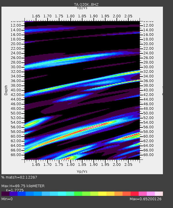
| Estimated Moho Depth: |
69.75 km |
| Estimated Crust Vp/Vs: |
1.77 |
| Assumed Crust Vp: |
5.989 km/s |
| Estimated Crust Vs: |
3.379 km/s |
| Estimated Crust Poisson's Ratio: |
0.27 |
|
| Radial Match: |
82.12267 % |
| Radial Bump: |
400 |
| Transverse Match: |
60.712593 % |
| Transverse Bump: |
400 |
| SOD ConfigId: |
19053131 |
| Insert Time: |
2019-08-19 09:12:43.433 +0000 |
| GWidth: |
2.5 |
| Max Bumps: |
400 |
| Tol: |
0.001 |
|

Signal To Noise
| Channel | StoN | STA | LTA |
| TA:Q20K: :BHZ:20190805T09:12:45.850021Z | 6.004848 | 1.3533712E-6 | 2.2537978E-7 |
| TA:Q20K: :BHN:20190805T09:12:45.850021Z | 2.6281767 | 5.6966206E-7 | 2.1675183E-7 |
| TA:Q20K: :BHE:20190805T09:12:45.850021Z | 1.4261122 | 3.6316248E-7 | 2.546521E-7 |
| Arrivals |
| Ps | 9.2 SECOND |
| PpPs | 32 SECOND |
| PsPs/PpSs | 41 SECOND |


