You are here: Home > Network List > IU - Global Seismograph Network (GSN - IRIS/USGS) Stations List
> Station XMAS Kiritimati Island, Republic of Kiribati > Earthquake Result Viewer
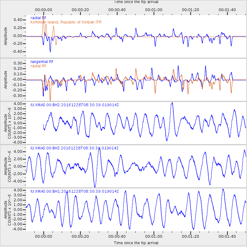
XMAS Kiritimati Island, Republic of Kiribati - Earthquake Result Viewer
*The percent match for this event was below the threshold and hence no stack was calculated.
| Earthquake location: |
California-Nevada Border Region |
| Earthquake latitude/longitude: |
38.4/-118.9 |
| Earthquake time(UTC): |
2016/12/28 (363) 08:22:12 GMT |
| Earthquake Depth: |
12 km |
| Earthquake Magnitude: |
5.7 ml |
| Earthquake Catalog/Contributor: |
NEIC PDE/nn |
|
| Network: |
IU Global Seismograph Network (GSN - IRIS/USGS) |
| Station: |
XMAS Kiritimati Island, Republic of Kiribati |
| Lat/Lon: |
2.04 N/157.45 W |
| Elevation: |
20 m |
|
| Distance: |
50.5 deg |
| Az: |
233.819 deg |
| Baz: |
39.396 deg |
| Ray Param: |
$rayparam |
*The percent match for this event was below the threshold and hence was not used in the summary stack. |
|
| Radial Match: |
57.69487 % |
| Radial Bump: |
400 |
| Transverse Match: |
51.362034 % |
| Transverse Bump: |
400 |
| SOD ConfigId: |
1943534 |
| Insert Time: |
2017-01-11 08:23:47.833 +0000 |
| GWidth: |
2.5 |
| Max Bumps: |
400 |
| Tol: |
0.001 |
|
Signal To Noise
| Channel | StoN | STA | LTA |
| IU:XMAS:00:BHZ:20161228T08:30:39.019014Z | 1.7203137 | 2.7461517E-6 | 1.5963086E-6 |
| IU:XMAS:00:BH1:20161228T08:30:39.019014Z | 0.5439063 | 8.7663676E-7 | 1.6117423E-6 |
| IU:XMAS:00:BH2:20161228T08:30:39.019014Z | 0.81891567 | 1.0719018E-6 | 1.3089283E-6 |
| Arrivals |
| Ps | |
| PpPs | |
| PsPs/PpSs | |


