You are here: Home > Network List > TX - Texas Seismological Network Stations List
> Station MB02 Rankin > Earthquake Result Viewer
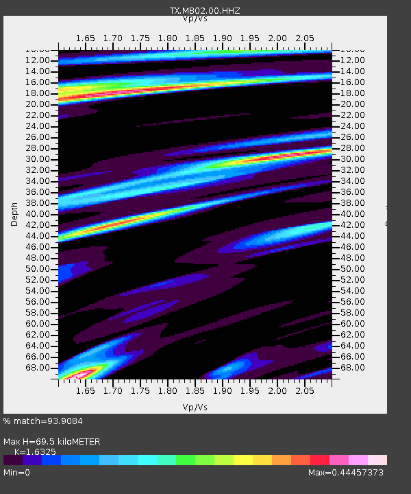
MB02 Rankin - Earthquake Result Viewer
| Earthquake location: |
Tonga Islands |
| Earthquake latitude/longitude: |
-19.4/-174.9 |
| Earthquake time(UTC): |
2019/08/05 (217) 09:01:08 GMT |
| Earthquake Depth: |
10 km |
| Earthquake Magnitude: |
5.7 mb |
| Earthquake Catalog/Contributor: |
NEIC PDE/us |
|
| Network: |
TX Texas Seismological Network |
| Station: |
MB02 Rankin |
| Lat/Lon: |
31.20 N/102.04 W |
| Elevation: |
768 m |
|
| Distance: |
86.0 deg |
| Az: |
55.157 deg |
| Baz: |
244.73 deg |
| Ray Param: |
0.0443281 |
| Estimated Moho Depth: |
69.5 km |
| Estimated Crust Vp/Vs: |
1.63 |
| Assumed Crust Vp: |
6.121 km/s |
| Estimated Crust Vs: |
3.749 km/s |
| Estimated Crust Poisson's Ratio: |
0.20 |
|
| Radial Match: |
93.9084 % |
| Radial Bump: |
237 |
| Transverse Match: |
87.551926 % |
| Transverse Bump: |
385 |
| SOD ConfigId: |
19053131 |
| Insert Time: |
2019-08-19 09:13:22.345 +0000 |
| GWidth: |
2.5 |
| Max Bumps: |
400 |
| Tol: |
0.001 |
|

Signal To Noise
| Channel | StoN | STA | LTA |
| TX:MB02:00:HHZ:20190805T09:13:17.749984Z | 21.273687 | 7.2128495E-7 | 3.3905025E-8 |
| TX:MB02:00:HH1:20190805T09:13:17.749984Z | 8.4995985 | 1.6296676E-7 | 1.9173465E-8 |
| TX:MB02:00:HH2:20190805T09:13:17.749984Z | 8.500064 | 2.028452E-7 | 2.3863961E-8 |
| Arrivals |
| Ps | 7.4 SECOND |
| PpPs | 29 SECOND |
| PsPs/PpSs | 37 SECOND |


