You are here: Home > Network List > TX - Texas Seismological Network Stations List
> Station PB19 West of Imperial > Earthquake Result Viewer
PB19 West of Imperial - Earthquake Result Viewer
| Earthquake location: |
Tonga Islands |
| Earthquake latitude/longitude: |
-19.4/-174.9 |
| Earthquake time(UTC): |
2019/08/05 (217) 09:01:08 GMT |
| Earthquake Depth: |
10 km |
| Earthquake Magnitude: |
5.7 mb |
| Earthquake Catalog/Contributor: |
NEIC PDE/us |
|
| Network: |
TX Texas Seismological Network |
| Station: |
PB19 West of Imperial |
| Lat/Lon: |
31.30 N/103.10 W |
| Elevation: |
782 m |
|
| Distance: |
85.3 deg |
| Az: |
54.669 deg |
| Baz: |
244.145 deg |
| Ray Param: |
0.04488235 |
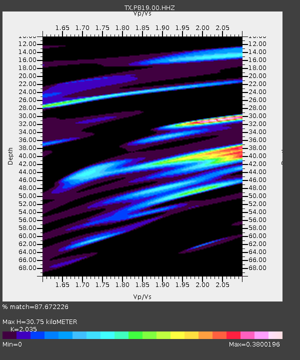
| Estimated Moho Depth: |
30.75 km |
| Estimated Crust Vp/Vs: |
2.04 |
| Assumed Crust Vp: |
6.121 km/s |
| Estimated Crust Vs: |
3.008 km/s |
| Estimated Crust Poisson's Ratio: |
0.34 |
|
| Radial Match: |
87.672226 % |
| Radial Bump: |
400 |
| Transverse Match: |
58.719486 % |
| Transverse Bump: |
400 |
| SOD ConfigId: |
19053131 |
| Insert Time: |
2019-08-19 09:13:43.310 +0000 |
| GWidth: |
2.5 |
| Max Bumps: |
400 |
| Tol: |
0.001 |
|

Signal To Noise
| Channel | StoN | STA | LTA |
| TX:PB19:00:HHZ:20190805T09:13:13.910018Z | 18.493778 | 500.5758 | 27.067255 |
| TX:PB19:00:HHN:20190805T09:13:13.910018Z | 2.3379495 | 59.23006 | 25.334192 |
| TX:PB19:00:HHE:20190805T09:13:13.910018Z | 5.473457 | 142.441 | 26.023954 |
| Arrivals |
| Ps | 5.3 SECOND |
| PpPs | 15 SECOND |
| PsPs/PpSs | 20 SECOND |


