You are here: Home > Network List > US - United States National Seismic Network Stations List
> Station DGMT Dagmar, Montana, USA > Earthquake Result Viewer
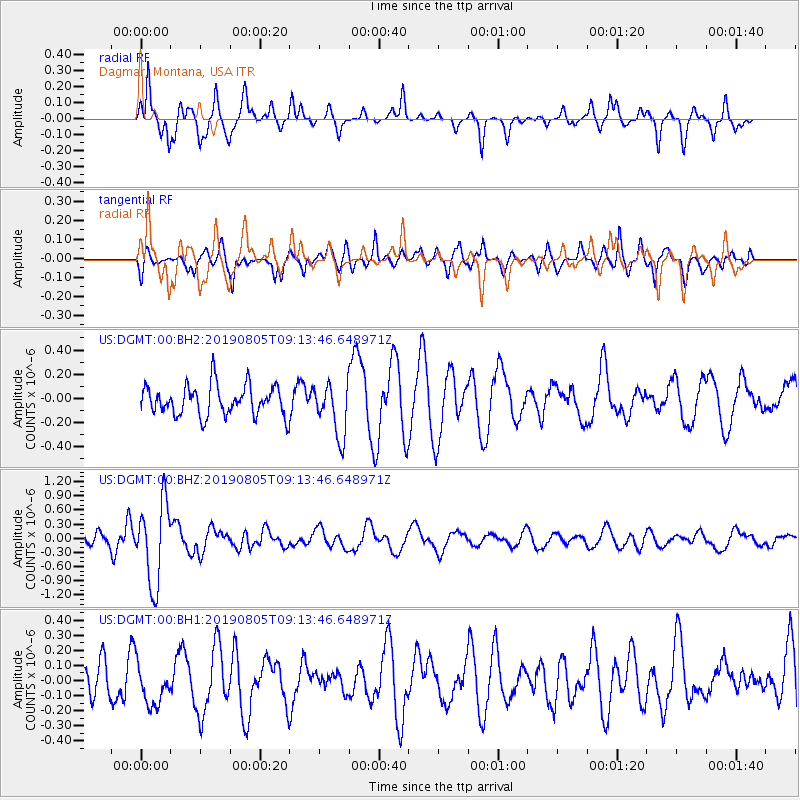
DGMT Dagmar, Montana, USA - Earthquake Result Viewer
*The percent match for this event was below the threshold and hence no stack was calculated.
| Earthquake location: |
Tonga Islands |
| Earthquake latitude/longitude: |
-19.4/-174.9 |
| Earthquake time(UTC): |
2019/08/05 (217) 09:01:08 GMT |
| Earthquake Depth: |
10 km |
| Earthquake Magnitude: |
5.7 mb |
| Earthquake Catalog/Contributor: |
NEIC PDE/us |
|
| Network: |
US United States National Seismic Network |
| Station: |
DGMT Dagmar, Montana, USA |
| Lat/Lon: |
48.47 N/104.20 W |
| Elevation: |
0.0 m |
|
| Distance: |
92.2 deg |
| Az: |
38.939 deg |
| Baz: |
243.085 deg |
| Ray Param: |
$rayparam |
*The percent match for this event was below the threshold and hence was not used in the summary stack. |
|
| Radial Match: |
74.06653 % |
| Radial Bump: |
310 |
| Transverse Match: |
56.539936 % |
| Transverse Bump: |
400 |
| SOD ConfigId: |
19053131 |
| Insert Time: |
2019-08-19 09:14:02.776 +0000 |
| GWidth: |
2.5 |
| Max Bumps: |
400 |
| Tol: |
0.001 |
|
Signal To Noise
| Channel | StoN | STA | LTA |
| US:DGMT:00:BHZ:20190805T09:13:46.648971Z | 9.501107 | 8.6292863E-7 | 9.082401E-8 |
| US:DGMT:00:BH1:20190805T09:13:46.648971Z | 1.2492523 | 1.3706284E-7 | 1.09715906E-7 |
| US:DGMT:00:BH2:20190805T09:13:46.648971Z | 1.7590482 | 2.1891461E-7 | 1.2445061E-7 |
| Arrivals |
| Ps | |
| PpPs | |
| PsPs/PpSs | |


