You are here: Home > Network List > US - United States National Seismic Network Stations List
> Station MNTX Cornudas Mountains, Texas, USA > Earthquake Result Viewer
MNTX Cornudas Mountains, Texas, USA - Earthquake Result Viewer
| Earthquake location: |
Tonga Islands |
| Earthquake latitude/longitude: |
-19.4/-174.9 |
| Earthquake time(UTC): |
2019/08/05 (217) 09:01:08 GMT |
| Earthquake Depth: |
10 km |
| Earthquake Magnitude: |
5.7 mb |
| Earthquake Catalog/Contributor: |
NEIC PDE/us |
|
| Network: |
US United States National Seismic Network |
| Station: |
MNTX Cornudas Mountains, Texas, USA |
| Lat/Lon: |
31.70 N/105.38 W |
| Elevation: |
404 m |
|
| Distance: |
83.7 deg |
| Az: |
53.441 deg |
| Baz: |
242.84 deg |
| Ray Param: |
0.04599812 |
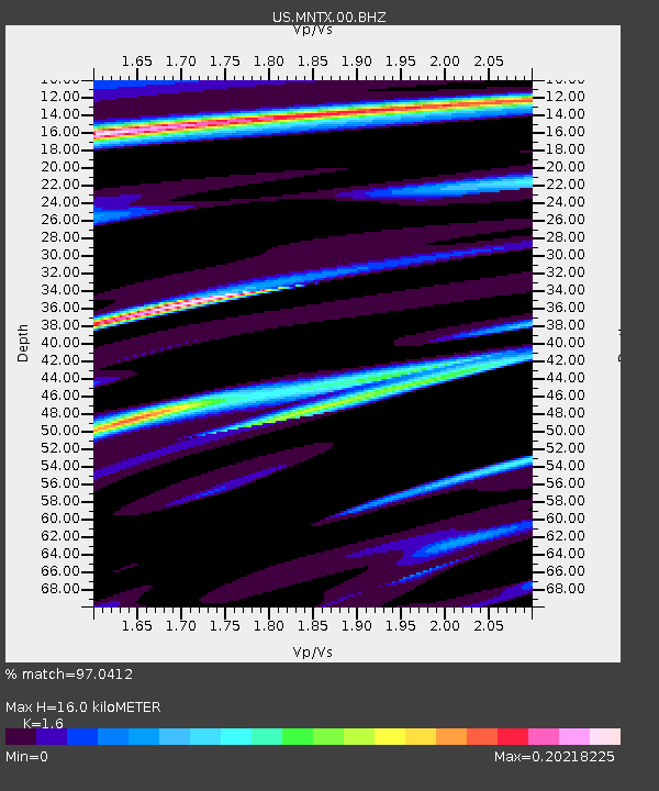
| Estimated Moho Depth: |
16.0 km |
| Estimated Crust Vp/Vs: |
1.60 |
| Assumed Crust Vp: |
6.361 km/s |
| Estimated Crust Vs: |
3.975 km/s |
| Estimated Crust Poisson's Ratio: |
0.18 |
|
| Radial Match: |
97.0412 % |
| Radial Bump: |
266 |
| Transverse Match: |
89.06889 % |
| Transverse Bump: |
338 |
| SOD ConfigId: |
19053131 |
| Insert Time: |
2019-08-19 09:14:10.813 +0000 |
| GWidth: |
2.5 |
| Max Bumps: |
400 |
| Tol: |
0.001 |
|

Signal To Noise
| Channel | StoN | STA | LTA |
| US:MNTX:00:BHZ:20190805T09:13:05.999007Z | 13.728794 | 1.2705572E-6 | 9.2546884E-8 |
| US:MNTX:00:BH1:20190805T09:13:05.999007Z | 1.9657826 | 8.4165876E-8 | 4.2815454E-8 |
| US:MNTX:00:BH2:20190805T09:13:05.999007Z | 7.700273 | 4.054707E-7 | 5.2656667E-8 |
| Arrivals |
| Ps | 1.6 SECOND |
| PpPs | 6.4 SECOND |
| PsPs/PpSs | 7.9 SECOND |


